
軽井沢町 topographic map
Interactive map
Click on the map to display elevation.
About this map
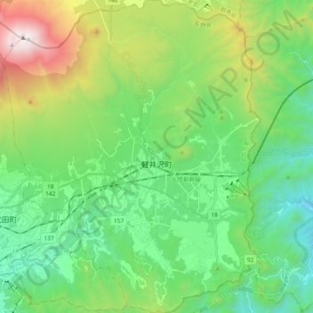
Name: 軽井沢町 topographic map, elevation, terrain.
Location: 軽井沢町, 北佐久郡, 長野県, 中部地方, 日本 (36.27840 138.50749 36.42439 138.65716)
Average elevation: 1,117 m
Minimum elevation: 535 m
Maximum elevation: 2,563 m
四方を山や丘陵に囲まれた高原であり、起伏豊かな地形を形成している。また水資源が豊富であり、町内には滝や、河川を堰き止めた湖・池が多く見られる(#景勝地参照)。町の北側一帯は上信越高原国立公園であり、重要野鳥生息地(IBA)、国指定鳥獣保護区に指定されている。
Other topographic maps
Click on a map to view its topography, its elevation and its terrain.