
Fukushima Prefecture topographic map
Interactive map
Click on the map to display elevation.
About this map
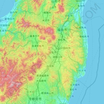
Name: Fukushima Prefecture topographic map, elevation, terrain.
Location: Fukushima Prefecture, Japan (36.74434 139.16474 37.98860 141.43766)
Average elevation: 402 m
Minimum elevation: -3 m
Maximum elevation: 2,554 m
Fukushima city is located in the Fukushima Basin's southwest area and nearby mountains. Aizuwakamatsu is located in the western part of Fukushima Prefecture, in the southeast part of Aizu basin. Mount Bandai is the highest mountain in the prefecture with an elevation of 1,819 m (5,968 ft). Mount Azuma-kofuji is an active stratovolcano that is 1,705 m (5,594 ft) tall with many onsen nearby. Lake Inawashiro is the 4th largest lake of Japan (103.3 km2 (39.9 sq mi)) in the center of the prefecture.
Other topographic maps
Click on a map to view its topography, its elevation and its terrain.
Motoyama
Motoyama, Nagaoka County, Kochi Prefecture, 781-3601, Japan
Average elevation: 679 m
Niki
Niki, Yoichi County, Shiribeshi Subprefecture, Hokkaido Prefecture, Japan
Average elevation: 269 m
Kusatsu
Kusatsu, Agatsuma County, Gunma Prefecture, Japan
Average elevation: 1,171 m
Kansai Region
Japan > Chubu Region > Nagoya
Kansai Region, Joto, Osaka Prefecture, Japan
Average elevation: 194 m
Nidan Fall
Nidan Fall, Matsumoto, Nagano Prefecture, Japan
Average elevation: 2,048 m
Jodogahama Observation Spot
Jodogahama Observation Spot, 浄土ヶ浜自然歩道, 鍬ヶ崎, Miyako, Iwate Prefecture, 027-0076, Japan
Average elevation: 22 m
Tsuwano
Tsuwano, Kanoashi County, Shimane Prefecture, Japan
Average elevation: 330 m