
Xiangkhouang Province topographic map
Interactive map
Click on the map to display elevation.
About this map
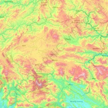
Name: Xiangkhouang Province topographic map, elevation, terrain.
Location: Xiangkhouang Province, Laos (18.79526 102.65091 20.04067 104.28077)
Average elevation: 1,001 m
Minimum elevation: 169 m
Maximum elevation: 2,757 m
Xiangkhouang province covers an area of 15,880 square kilometres (6,130 sq mi) and is mountainous. Apart from floodplains, the largest area of level land in the country is on the province's Xiangkhoang Plateau. The plateau is characterized by rolling hills and grassland whose elevation averages 1,300 metres (4,300 ft). The country's highest peak, Phou Bia (2,820 metres (9,250 ft)), rises at the south side of the plateau. Nam Et-Phou Louey is a National Biodiversity Conservation Area (NBCA) in the province, covering an area of 5,959 km2, and overlaps into Houaphanh and Luang Prabang provinces.
Other topographic maps
Click on a map to view its topography, its elevation and its terrain.
Khonkaen
Laos > Champasak Province > Champassack District
Khonkaen, Champassack District, Champasak Province, Laos
Average elevation: 153 m
Hatsadi
Laos > Vientiane Prefecture > Chanthabuly District > Vientiane Capital
Hatsadi, Vientiane Capital, Chanthabuly District, Vientiane Prefecture, 01003, Laos
Average elevation: 170 m
Thanaleng
Laos > Vientiane Prefecture > Hadxayfong District
Dongphosy, Thanaleng, Hadxayfong District, Vientiane Prefecture, Laos
Average elevation: 168 m
Dongpalane Thong
Laos > Vientiane Prefecture > Sisattanak District
Fay Village, Dongpalane Thong, Sisattanak District, Vientiane Prefecture, 01003, Laos
Average elevation: 171 m
Xayabury District
Xayabury District, Sainyabuli Province, Laos
Average elevation: 754 m
Ban Nagno
Laos > Khammouane > Thakhek District
Ban Nagno, Thakhek District, Khammouane, Laos
Average elevation: 275 m
Vientiane
Laos > Vientiane Prefecture > Vientiane
Vientiane, Vientiane Capital, Chanthabuly District, Vientiane Prefecture, 01003, Laos
Average elevation: 175 m
Vientiane Capital
Laos > Vientiane Prefecture > Chanthabuly District
Vientiane Capital, Chanthabuly District, Vientiane Prefecture, Laos
Average elevation: 187 m
Muang Sing
Laos > Luang Namtha > Muang Sing
Muang Sing, Sing District, Luang Namtha, Laos
Average elevation: 663 m
Hom District
Hom District, Xaisomboun Province, Laos
Average elevation: 797 m
Nachan
Laos > Salavan Province > Nachan
Nachan, Vapy District, Salavan Province, Laos
Average elevation: 226 m
Namsang
Laos > Bolikhamsai > Namsang
Namsang, Pakkading District, Bolikhamsai, Laos
Average elevation: 162 m