
Make a donation
Attapeu topographic map
Click on the map to display elevation.
Make a donation
Attapeu
Dong Ampham National Biodiversity Conservation Area (NBCA) is the protected area which lies in Attapeu province (on the northeastern part) and Sekong province (on the southeastern part). It is in the southeast corner of Laos on the border with Vietnam. The NBCA is heavily forested and covers about 200,000 hectares. Established in 1993, it is one of the 23 National Biodiversity Conservation Areas of Laos. Dong Ampham is home to "some of the last intact areas of lowland and tropical forests remaining in mainland Southeast Asia." Topographical features include Xe Kaman and Xe Xou Rivers, and the volcanic lake Nong Fa Lake. Tigers and Clouded leopard are recorded fauna in remote areas.
Make a donation
About this map
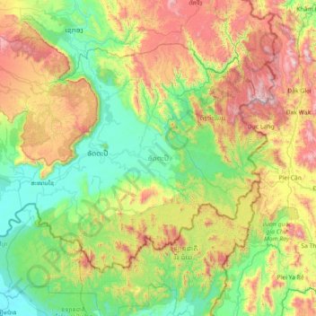
Name: Attapeu topographic map, elevation, terrain.
Location: Attapeu, Laos (14.29232 106.17017 15.28861 107.59147)
Average elevation: 599 m
Minimum elevation: 62 m
Maximum elevation: 1,967 m
Make a donation
Other topographic maps
Click on a map to view its topography, its elevation and its terrain.
Sengsavang
Laos > Vientiane Prefecture > Xaysetha District > Vientiane Capital
Average elevation: 171 m
Make a donation
B. Phonthongchommani
Laos > Vientiane Prefecture > Chanthabuly District > Vientiane Capital
Average elevation: 173 m
Make a donation
B. Phonsavang
Laos > Vientiane Prefecture > Chanthabuly District > Vientiane Capital
Average elevation: 174 m
Phonpapao
Laos > Vientiane Prefecture > Sisattanak District > Vientiane Capital
Average elevation: 170 m
Make a donation
Hatsadi
Laos > Vientiane Prefecture > Chanthabuly District > Vientiane Capital
Average elevation: 170 m
Make a donation