
Make a donation
Luang Prabang topographic map
Click on the map to display elevation.
Make a donation
Luang Prabang
The 60,070 hectare Phou Louey Massif Important Bird Area (IBA) is in the Nam Et-Phou Louey National Biodiversity Conservation Area (NBCA). The IBA is in the provinces of Luang Prabang and Houaphanh. It sits at an elevation of 700–1,800 metres (2,300–5,900 ft). The habitat contains mixed deciduous forest, semi-evergreen forest, lower montane evergreen forest, upper montane evergreen forest, and secondary grassland. Notable avifauna include beautiful nuthatch Sitta formosa, Blyth's kingfisher Alcedo hercules, rufous-necked hornbill Aceros nipalensis, and yellow-vented warbler Phylloscopus cantator.
Make a donation
About this map
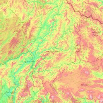
Name: Luang Prabang topographic map, elevation, terrain.
Location: Luang Prabang, Laos (19.04225 101.72238 21.13570 103.40047)
Average elevation: 910 m
Minimum elevation: 236 m
Maximum elevation: 2,481 m
Make a donation
Other topographic maps
Click on a map to view its topography, its elevation and its terrain.
Sengsavang
Laos > Vientiane Prefecture > Xaysetha District > Vientiane Capital
Average elevation: 171 m
Make a donation
B. Phonthongchommani
Laos > Vientiane Prefecture > Chanthabuly District > Vientiane Capital
Average elevation: 173 m
Make a donation
B. Phonsavang
Laos > Vientiane Prefecture > Chanthabuly District > Vientiane Capital
Average elevation: 174 m
Phonpapao
Laos > Vientiane Prefecture > Sisattanak District > Vientiane Capital
Average elevation: 170 m
Make a donation
Hatsadi
Laos > Vientiane Prefecture > Chanthabuly District > Vientiane Capital
Average elevation: 170 m
Make a donation