
Sekong Province topographic map
Interactive map
Click on the map to display elevation.
About this map
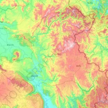
Name: Sekong Province topographic map, elevation, terrain.
Location: Sekong Province, Laos (15.02836 106.30008 16.18952 107.63500)
Average elevation: 771 m
Minimum elevation: 94 m
Maximum elevation: 2,170 m
The Dakchung Plateau is an Important Bird Area (IBA). It is 5,140 ha in size, and at an elevation of 800–1,400 metres (2,600–4,600 ft). The habitat is characterized as pine woodland, grassland, degraded semi-evergreen forest, dry evergreen forest, marshy land, and tall grasses areas. Of the avifauna, the yellow-billed nuthatch (Sitta solangiae) is classified as near threatened, while the black-crowned barwing (Actinodura sodangorum) is classified as vulnerable. Other fauna include the Oriental small-clawed otter (Aonyx cinerea), tiger (Panthera tigris), big-headed turtle (Platysternon megacephalum), and herds of Asian elephant (Elephas maximus).
Other topographic maps
Click on a map to view its topography, its elevation and its terrain.
Khonkaen
Laos > Champasak Province > Champassack District
Khonkaen, Champassack District, Champasak Province, Laos
Average elevation: 153 m
Hatsadi
Laos > Vientiane Prefecture > Chanthabuly District > Vientiane Capital
Hatsadi, Vientiane Capital, Chanthabuly District, Vientiane Prefecture, 01003, Laos
Average elevation: 170 m
Thanaleng
Laos > Vientiane Prefecture > Hadxayfong District
Dongphosy, Thanaleng, Hadxayfong District, Vientiane Prefecture, Laos
Average elevation: 168 m
Dongpalane Thong
Laos > Vientiane Prefecture > Sisattanak District
Fay Village, Dongpalane Thong, Sisattanak District, Vientiane Prefecture, 01003, Laos
Average elevation: 171 m
Xayabury District
Xayabury District, Sainyabuli Province, Laos
Average elevation: 754 m
Ban Nagno
Laos > Khammouane > Thakhek District
Ban Nagno, Thakhek District, Khammouane, Laos
Average elevation: 275 m
Vientiane
Laos > Vientiane Prefecture > Vientiane
Vientiane, Vientiane Capital, Chanthabuly District, Vientiane Prefecture, 01003, Laos
Average elevation: 175 m
Vientiane Capital
Laos > Vientiane Prefecture > Chanthabuly District
Vientiane Capital, Chanthabuly District, Vientiane Prefecture, Laos
Average elevation: 187 m
Muang Sing
Laos > Luang Namtha > Muang Sing
Muang Sing, Sing District, Luang Namtha, Laos
Average elevation: 663 m
Hom District
Hom District, Xaisomboun Province, Laos
Average elevation: 797 m
Nachan
Laos > Salavan Province > Nachan
Nachan, Vapy District, Salavan Province, Laos
Average elevation: 226 m
Namsang
Laos > Bolikhamsai > Namsang
Namsang, Pakkading District, Bolikhamsai, Laos
Average elevation: 162 m