
Make a donation
Oudomxay topographic map
Click on the map to display elevation.
Make a donation
Oudomxay
It covers an area of 15,370 square kilometres (5,930 sq mi). It borders China to the north, Phongsali province to the northeast, Luang Prabang province to the east and southeast, Xaignabouli province to the south and southwest, Bokeo province to the west, and Luang Namtha province to the northwest. Its topography is mountainous, between 300–1,800 metres (980–5,910 ft) above sea level.
Make a donation
About this map
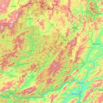
Name: Oudomxay topographic map, elevation, terrain.
Location: Oudomxay, Laos (19.81782 100.72712 21.21457 102.35779)
Average elevation: 834 m
Minimum elevation: 267 m
Maximum elevation: 2,008 m
Make a donation
Other topographic maps
Click on a map to view its topography, its elevation and its terrain.
Sengsavang
Laos > Vientiane Prefecture > Xaysetha District > Vientiane Capital
Average elevation: 171 m
Make a donation
B. Phonthongchommani
Laos > Vientiane Prefecture > Chanthabuly District > Vientiane Capital
Average elevation: 173 m
Make a donation
B. Phonsavang
Laos > Vientiane Prefecture > Chanthabuly District > Vientiane Capital
Average elevation: 174 m
Phonpapao
Laos > Vientiane Prefecture > Sisattanak District > Vientiane Capital
Average elevation: 170 m
Make a donation
Hatsadi
Laos > Vientiane Prefecture > Chanthabuly District > Vientiane Capital
Average elevation: 170 m
Make a donation