
Make a donation
Phongsaly topographic map
Click on the map to display elevation.
Make a donation
Phongsaly
Phongsaly province covers an area of 16,270 square kilometres (6,280 sq mi), out of which 77% has forest cover. The province borders China to the north and west, Vietnam to the east, Luang Prabang province to the south, and Oudomxai province to the southwest. The highest mountain in the province is Phou Doychy with an elevation of 1,842 metres (6,043 ft) Protected areas in the province include the Phou Dene Din National Biodiversity Conservation Area and Nam Lan Conservation Area. Agriculture is the mainstay of the people of the province. Phongsaly is the primary trade gateway between Laos and China, exporting lumber and importing several types of finished goods.
Make a donation
About this map
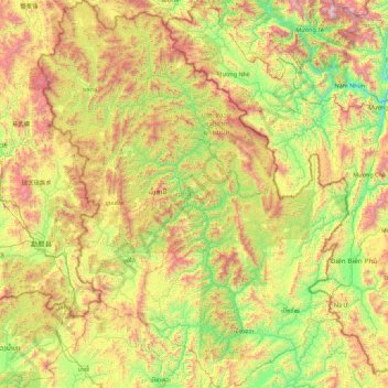
Name: Phongsaly topographic map, elevation, terrain.
Location: Phongsaly, Laos (20.83346 101.54921 22.50867 102.99287)
Average elevation: 933 m
Minimum elevation: 198 m
Maximum elevation: 2,492 m
Make a donation
Other topographic maps
Click on a map to view its topography, its elevation and its terrain.
Sengsavang
Laos > Vientiane Prefecture > Xaysetha District > Vientiane Capital
Average elevation: 171 m
Make a donation
B. Phonthongchommani
Laos > Vientiane Prefecture > Chanthabuly District > Vientiane Capital
Average elevation: 173 m
Make a donation
B. Phonsavang
Laos > Vientiane Prefecture > Chanthabuly District > Vientiane Capital
Average elevation: 174 m
Phonpapao
Laos > Vientiane Prefecture > Sisattanak District > Vientiane Capital
Average elevation: 170 m
Make a donation
Hatsadi
Laos > Vientiane Prefecture > Chanthabuly District > Vientiane Capital
Average elevation: 170 m
Make a donation