
Make a donation
Vientiane Province topographic map
Click on the map to display elevation.
Make a donation
Vientiane Province
Phou Khao Khouay National Biodiversity Conservation Area is a protected area 40 kilometres (25 mi) northeast of Vientiane. It was established on 29 October 1993 covering an area of 2,000 km2 extending into Khet Phiset Xaisomboon (special zone), Vientiane prefecture, and Vientiane province. Its mountainous topography, with elevation varying from 200 m to 1761 m, emerged from "uplifting and exposure of the underlying sedimentary (Indosinias schist-clay-sandstone) complex". Sandstone is also seen spread in layers. extensive flat uplands with sandstones with hardly any soil cover are also part of the topography of the park. It has a large stretch of mountain range with sandstone cliffs, river gorges and three large rivers with tributaries which flow into the Mekong River. It has monsoonal climate with recorded annual rainfall of 1936 mm (with higher reaches recording more rainfall). The mean annual temperature is 26.6 °C with a mean maximum of 31.6 °C and a mean minimum temperature of 21.5 °C. The forests are evergreen, Shorea mixed deciduous forest, dry dipterocarp and pine type; particularly coniferous forest, of mono specific stands of Pinus merkusii, Fokienia hodgsonsii, bamboo (mai sanod), and fire-climax grasslands. Animals found here include elephants, tigers, bears, white-cheeked gibbons, and langurs and many species of reptiles, amphibians, and birds. The green peafowl has been reported here, near Ban Nakhay and Ban Nakhan Thoung, although it was generally considered to be extinct in Laos; conservation management has increased its population.
Make a donation
About this map
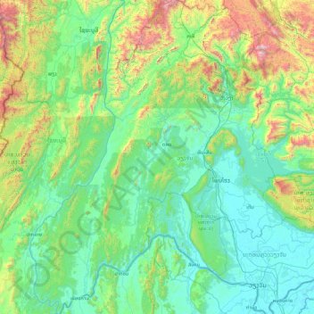
Name: Vientiane Province topographic map, elevation, terrain.
Location: Vientiane Province, Laos (17.81354 101.38624 19.41357 102.89857)
Average elevation: 526 m
Minimum elevation: 158 m
Maximum elevation: 2,428 m
Make a donation
Other topographic maps
Click on a map to view its topography, its elevation and its terrain.
Make a donation
B. Haysok
Laos > Vientiane Prefecture > Chanthabuly District > Vientiane Capital
Average elevation: 170 m
Make a donation
Make a donation
Saphangmo
Laos > Vientiane Prefecture > Xaysetha District > Vientiane Capital
Average elevation: 170 m
Make a donation
Donnokkhoum
Laos > Vientiane Prefecture > Sisattanak District > Vientiane Capital
Average elevation: 170 m
Phonsinouan
Laos > Vientiane Prefecture > Sisattanak District > Vientiane Capital
Average elevation: 170 m
Make a donation
Nongtaeng
Laos > Vientiane Prefecture > Sikhottabong District > Vientiane Capital
Average elevation: 174 m
Make a donation
Dongkhamxang
Laos > Vientiane Prefecture > Hadxayfong District > Vientiane Capital
Average elevation: 172 m
Nonghai
Laos > Vientiane Prefecture > Hadxayfong District > Vientiane Capital
Average elevation: 172 m
Make a donation
Muangvatha
Laos > Vientiane Prefecture > Sikhottabong District > Vientiane Capital
Average elevation: 169 m
Dognaxoyneua
Laos > Vientiane Prefecture > Sikhottabong District > Vientiane Capital
Average elevation: 169 m
Make a donation
ທົ່ງປົງ
Laos > Vientiane Prefecture > Sikhottabong District > Vientiane Capital
Average elevation: 174 m
Make a donation
Nongtha Marsh
Laos > Vientiane Prefecture > Chanthabuly District > Vientiane Capital > B. Nongthanua
Average elevation: 175 m
Don Koy
Laos > Vientiane Prefecture > Sisattanak District > Vientiane Capital
Average elevation: 169 m
Chommanytai
Laos > Vientiane Prefecture > Xaysetha District > Vientiane Capital
Average elevation: 172 m
Make a donation
Make a donation
Make a donation
Dongphosy
Laos > Vientiane Prefecture > Hadxayfong District > Vientiane Capital
Average elevation: 168 m
Make a donation
Make a donation
Make a donation
Make a donation
Make a donation
Make a donation
Thatlouangkang
Laos > Vientiane Prefecture > Xaysetha District > Vientiane Capital
Average elevation: 170 m
Make a donation
Make a donation
Make a donation
Xiangkhouang
Xiangkhouang province covers an area of 15,880 square kilometres (6,130 sq mi) and is mountainous. Apart from floodplains, the largest area of level land in the country is on the province's Xiangkhoang Plateau. The plateau is characterized by rolling hills and grassland whose elevation averages 1,300 metres…
Average elevation: 565 m
Make a donation
Sibounheuang
Laos > Vientiane Prefecture > Chanthabuly District > Sibounheuang
Average elevation: 171 m
Make a donation
Make a donation
Make a donation