
Make a donation
Salavan Province topographic map
Click on the map to display elevation.
Make a donation
Salavan Province
Its origin is volcanic with mountains and wide valleys. The central part of the province is located on the Bolaven Plateau, which is a key agricultural area with Arabica coffee as the dominant cash crop and other horticultural products which are exported. The western part of Salavan province is delimited by the Mekong river while the eastern part is delimited by the Lao-Vietnamese border. In addition to the Bolaven Plateau and the Mekong, the topography includes plains and a mountainous region near the border with Vietnam. The two protected areas in the province are the Xe Pian and Dong Ampham.
Make a donation
About this map
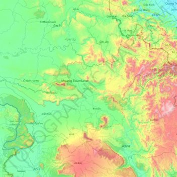
Name: Salavan Province topographic map, elevation, terrain.
Location: Salavan Province, Laos (15.27834 105.34223 16.54957 107.15709)
Average elevation: 469 m
Minimum elevation: 2 m
Maximum elevation: 2,170 m
Make a donation
Other topographic maps
Click on a map to view its topography, its elevation and its terrain.
Sengsavang
Laos > Vientiane Prefecture > Xaysetha District > Vientiane Capital
Average elevation: 171 m
Make a donation
B. Phonthongchommani
Laos > Vientiane Prefecture > Chanthabuly District > Vientiane Capital
Average elevation: 173 m
Make a donation
B. Phonsavang
Laos > Vientiane Prefecture > Chanthabuly District > Vientiane Capital
Average elevation: 174 m
Phonpapao
Laos > Vientiane Prefecture > Sisattanak District > Vientiane Capital
Average elevation: 170 m
Make a donation
Hatsadi
Laos > Vientiane Prefecture > Chanthabuly District > Vientiane Capital
Average elevation: 170 m
Make a donation