
Make a donation
Bokeo Province topographic map
Click on the map to display elevation.
Make a donation
Bokeo Province
The Bokeo Nature Reserve was created as protection for the black crested gibbon (also known as "black-cheeked gibbon"), discovered in 1997, previously thought to be extinct. Elephants and wild water buffalo migrate through the reserve; bears and tigers are also present. The protected area, is characterized by a mixed deciduous forest and mountainous terrain (elevation ranging between 500 and 1500 m). The area covered by the reserve is 136,000 ha, including 66,000 ha in Bokeo province and 70,000 ha in Luang Namtha province where critically endangered species of western black crested gibbon (Nomascus concolor) is the primary protected species. According to a preliminary survey, the number of gibbons is substantial, particularly in and around the uninhabited Nam Kan River and its tributaries. The project is being supported by the French entrepreneur Jean Francois Reumaux as a Gibbon Experience Project. Gibbon Experience is a conservation project that came into existence after the indigenous black-cheeked gibbon was discovered. The conservation programme has two components: one is of gibbon viewing huts, known as canopy huts (there are four such very large huts) in the forest reserve meant to view the black cheeked gibbons and the second component is to experience the rain forest at canopy level. The Waterfall Gibbon Experience involves three hours of hiking to the location, deep in the reserve following the Nam Nga River.
Make a donation
About this map
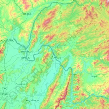
Name: Bokeo Province topographic map, elevation, terrain.
Location: Bokeo Province, Laos (19.76963 100.08432 20.84448 101.25529)
Average elevation: 609 m
Minimum elevation: 315 m
Maximum elevation: 1,970 m
Make a donation
Other topographic maps
Click on a map to view its topography, its elevation and its terrain.
Sengsavang
Laos > Vientiane Prefecture > Xaysetha District > Vientiane Capital
Average elevation: 171 m
Make a donation
B. Phonthongchommani
Laos > Vientiane Prefecture > Chanthabuly District > Vientiane Capital
Average elevation: 173 m
Make a donation
B. Phonsavang
Laos > Vientiane Prefecture > Chanthabuly District > Vientiane Capital
Average elevation: 174 m
Phonpapao
Laos > Vientiane Prefecture > Sisattanak District > Vientiane Capital
Average elevation: 170 m
Make a donation
Hatsadi
Laos > Vientiane Prefecture > Chanthabuly District > Vientiane Capital
Average elevation: 170 m
Make a donation