
Dumfries and Galloway topographic map
Interactive map
Click on the map to display elevation.
About this map
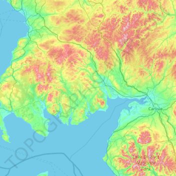
Name: Dumfries and Galloway topographic map, elevation, terrain.
Location: Dumfries and Galloway, Scotland, United Kingdom (54.63324 -5.18765 55.46405 -2.85733)
Average elevation: 163 m
Minimum elevation: -1 m
Maximum elevation: 921 m
Other topographic maps
Click on a map to view its topography, its elevation and its terrain.
Cumbernauld
United Kingdom > Scotland > North Lanarkshire
Cumbernauld's name probably comes from the Gaelic comar nan allt, meaning "meeting of the burns or streams". There are differing views as to the etymology of this. One theory is that from its high point in the Central Belt, its streams flow both west to the River Clyde and east to the Firth of Forth so…
Average elevation: 113 m
Tarbat Ness Lighthouse
United Kingdom > Scotland > Highland
The Tarbat Ness Lighthouse is located at the North West tip of the Tarbat Ness peninsula near the fishing village of Portmahomack on the east coast of Scotland. It was built in 1830 by Robert Stevenson and has an elevation of 53 metres (174 ft) and 203 steps to the top of the tower.
Average elevation: 5 m
Elgin
United Kingdom > Scotland > Moray
Elgin is first documented in the Cartulary of Moray in 1190 AD. It was created a royal burgh in the 12th century by King David I of Scotland, and by that time had a castle on top of the present-day Lady Hill to the west of the town. The origin of the name Elgin is likely to be Celtic. It may derive from…
Average elevation: 26 m
East Kilbride
United Kingdom > Scotland > South Lanarkshire
The earliest-known evidence of occupation in the area dates as far back as the late Neolithic and Early Bronze Age, as archaeological investigation has demonstrated that burial cairns in the district began as ceremonial or ritual sites of burial during the Neolithic, with the use of cup-marked, and other…
Average elevation: 175 m
Fort William
United Kingdom > Scotland > Highland
Fort William has an oceanic climate (Cfb) with moderate, but generally cool, temperatures and abundant precipitation. In the towns immediate vicinity, there are significant variations in elevation, which leads to some uninhabited areas near the town having a subpolar oceanic climate (Cfc), or, at the absolute…
Average elevation: 122 m
Lerwick
United Kingdom > Scotland > Lerwick
Lerwick has transitioned from a subpolar oceanic climate (Cfc) to a maritime climate (Cfb) with cool to cold temperatures all year long. The lack of trees reflects the latter type. This is particularly pronounced by virtue of Lerwick being on the coast of an island, so even extreme temperature records are…
Average elevation: 39 m
Dundee
United Kingdom > Scotland > Dundee City
Dundee sits on the north bank of the Firth of Tay on the eastern, North Sea Coast of Scotland. The city lies 36.1 miles (58 km) NNE of Edinburgh and 360.6 miles (580 km) NNW of London. The built-up area occupies a roughly rectangular shape 8.3 miles (13 km) long by 2.5 miles (4 km) wide, aligned in an east to…
Average elevation: 82 m
Aberdeen
United Kingdom > Scotland > Aberdeen City > Aberdeen
Two weather stations collect climate data for the area, Aberdeen/Dyce Airport, and Craibstone. Both are about 4+1⁄2 miles (7 km) to the north west of the city centre, and given that they are in close proximity to each other, exhibit very similar climatic regimes. Dyce tends to have marginally warmer daytime…
Average elevation: 52 m