
Thank you for supporting this site ❤️
Make a donation
Make a donation
Lochboisdale topographic map
Click on the map to display elevation.
Thank you for supporting this site ❤️
Make a donation
Make a donation
About this map
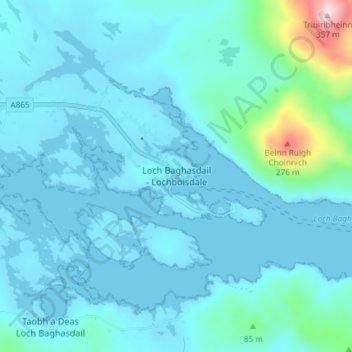
Name: Lochboisdale topographic map, elevation, terrain.
Location: Lochboisdale, Western Isles, Scotland, HS8 5TP, United Kingdom (57.13292 -7.32732 57.17292 -7.28732)
Average elevation: 36 m
Minimum elevation: -2 m
Maximum elevation: 350 m
Thank you for supporting this site ❤️
Make a donation
Make a donation
Other topographic maps
Click on a map to view its topography, its elevation and its terrain.