
Thank you for supporting this site ❤️
Make a donation
Make a donation
Cowdenbeath topographic map
Click on the map to display elevation.
Thank you for supporting this site ❤️
Make a donation
Make a donation
About this map
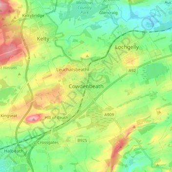
Name: Cowdenbeath topographic map, elevation, terrain.
Location: Cowdenbeath, Fife, Scotland, KY4 9NH, United Kingdom (56.07106 -3.38388 56.15106 -3.30388)
Average elevation: 130 m
Minimum elevation: 70 m
Maximum elevation: 242 m
Thank you for supporting this site ❤️
Make a donation
Make a donation
Other topographic maps
Click on a map to view its topography, its elevation and its terrain.