
Thank you for supporting this site ❤️
Make a donation
Make a donation
Macduff topographic map
Click on the map to display elevation.
Thank you for supporting this site ❤️
Make a donation
Make a donation
About this map
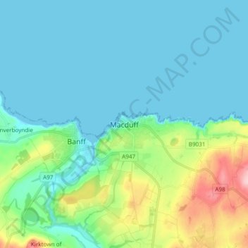
Name: Macduff topographic map, elevation, terrain.
Location: Macduff, Aberdeenshire, Scotland, AB44 1QN, United Kingdom (57.63021 -2.53444 57.71021 -2.45444)
Average elevation: 34 m
Minimum elevation: 0 m
Maximum elevation: 170 m
Thank you for supporting this site ❤️
Make a donation
Make a donation