
Laos topographic map
Interactive map
Click on the map to display elevation.
About this map
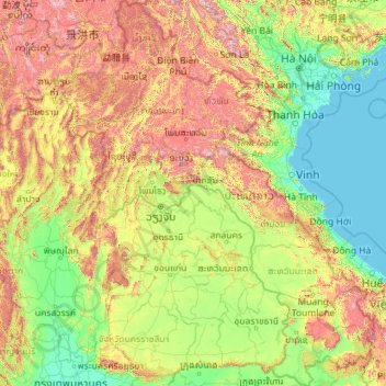
Name: Laos topographic map, elevation, terrain.
Location: Laos (13.90968 100.08432 22.50867 107.63500)
Average elevation: 432 m
Minimum elevation: -1 m
Maximum elevation: 2,808 m
The people of Laos are often categorised by their distribution by elevation: (lowlands, midlands and upper high lands) as this somewhat correlates with ethnic groupings. More than half of the nation's population is ethnic Lao—the principal lowland inhabitants, and the politically and culturally dominant people of Laos. The Lao belong to the Tai linguistic group who began migrating south from China in the first millennium CE. Ten percent belong to other "lowland" groups, which together with the Lao people make up the Lao Loum (lowland people).
Other topographic maps
Click on a map to view its topography, its elevation and its terrain.
India
India
Average elevation: 1,017 m
Hyderabad
India > Telangana > Bahadurpura mandal
Hyderabad, Bahadurpura mandal, Hyderabad District, Telangana, India
Average elevation: 549 m
Montreal
Canada > Quebec > Urban agglomeration of Montreal > Montreal
Montreal, Urban agglomeration of Montreal, Montreal (06), Quebec, H3B 1M7, Canada
Average elevation: 30 m
Sri Lanka
Sri Lanka
Average elevation: 50 m
Snohomish County
Snohomish County, Washington, United States
Average elevation: 649 m
Nepal
Nepal
Average elevation: 2,604 m
Ocheretyne
Ocheretyne, Ocheretyne settlement hromada, Pokrovskii Raion, Donetsk Oblast, 86020, Ukraine
Average elevation: 227 m
Dehradun
India > Uttarakhand > Dehradun
Dehradun, Dehradun District, Uttarakhand, 248001, India
Average elevation: 904 m
Copenhagen
Denmark > Capital Region of Denmark
Copenhagen, Copenhagen Municipality, Capital Region of Denmark, 1357, Denmark
Average elevation: 9 m
Noida
India > Uttar Pradesh > Dadri
Noida, Dadri, Gautam Buddha Nagar District, Uttar Pradesh, 201301, India
Average elevation: 216 m
Bengaluru
India > Karnataka > Bangalore North
Bengaluru, Bangalore North, Bengaluru Urban District, Karnataka, India
Average elevation: 881 m
Haywood County
United States > North Carolina
Haywood County, North Carolina, United States
Average elevation: 1,044 m
Ooty Lake
India > Tamil Nadu > Udhagamandalam > Udhagamandalam
Ooty Lake, Udhagamandalam, The Nilgiris District, Tamil Nadu, 643001, India
Average elevation: 2,235 m
Kandy
Kandy, Kandy District, Central Province, 20000, Sri Lanka
Average elevation: 621 m
Pune
India > Maharashtra > Pune City > Pune
Pune, Pune City, Pune District, Maharashtra, 411001, India
Average elevation: 641 m
Kovilanchery
India > Tamil Nadu > Tambaram
Kovilanchery, Tambaram, Chengalpattu District, Tamil Nadu, 600126, India
Average elevation: 11 m
Tacoma
United States > Washington > Pierce County
Tacoma, Pierce County, Washington, United States
Average elevation: 67 m
Hays County
United States of America > Texas
Hays County, Texas, United States of America
Average elevation: 285 m
Shangaime
Ecuador > Morona Santiago > Huamboya
Shangaime, Chiguaza, Huamboya, Morona Santiago, Ecuador
Average elevation: 810 m
Vairavanpatti
India > Tamil Nadu > Thiruppathur
Vairavanpatti, Thiruppathur, Sivagangai District, Tamil Nadu, 630207, India
Average elevation: 103 m
Chennai
India > Tamil Nadu > Chennai
Chennai, Chennai District, Tamil Nadu, India
Average elevation: 8 m
Winterborne Kingston
United Kingdom > England > Dorset
Winterborne Kingston, Dorset, England, United Kingdom
Average elevation: 77 m
Kadthal
India > Telangana > Soan mandal
Kadthal, Soan mandal, Nirmal District, Telangana, 504105, India
Average elevation: 318 m
Pedda Arikatla
India > Andhra Pradesh > Konakanamitla
Pedda Arikatla, Konakanamitla, Prakasam, Andhra Pradesh, 523245, India
Average elevation: 119 m
Devanahalli
India > Karnataka > Devanahalli taluk
Devanahalli, Devanahalli taluk, Bengaluru Rural District, Karnataka, 562110, India
Average elevation: 900 m
city de boutet de monvel (ethanlecartographe
France > Grand Est > Meurthe-et-Moselle > Lunéville
city de boutet de monvel (ethanlecartographe, Lunéville, Meurthe-et-Moselle, Grand Est, Metropolitan France, 54300, France
Average elevation: 240 m
Haraluru
India > Karnataka > Tumkur taluk
Haraluru, Tumkur taluk, Tumakuru District, Karnataka, India
Average elevation: 864 m