
Pauri Garhwal topographic map
Click on the map to display elevation.
Pauri Garhwal
The mountains of Khirsu offer views of the northern Himalayas and attract a large number of tourists. Located 19 kilometres (12 mi) away from Pauri at an altitude of 1,700 metres (5,600 ft), Khirsu is peaceful and free from pollution. There is the nearby ancient temple of Ghandiyal Devta. Accommodation is available at the Tourist Rest House, Forest Rest House, and private hotel.
About this map
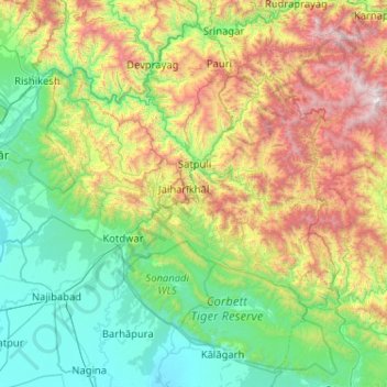
Name: Pauri Garhwal topographic map, elevation, terrain.
Location: Pauri Garhwal, Uttarakhand, India (29.43426 78.20209 30.26025 79.23187)
Average elevation: 958 m
Minimum elevation: 226 m
Maximum elevation: 3,068 m
Other topographic maps
Click on a map to view its topography, its elevation and its terrain.
Roopkund Lake
India > Uttarakhand > Chamoli Tehsil
Roopkund (locally known as Mystery Lake or Skeleton Lake) is a high altitude glacial lake in the Uttarakhand state of India. It lies in the lap of Trishul massif. Located in the Himalayas, the area around the lake is uninhabited and is roughly at an altitude of 5,020 metres (16,470 ft), surrounded by…
Average elevation: 4,631 m
Karnaprayag
India > Uttarakhand > Karnaprayag
Karnaprayag is located at 30°16′N 79°15′E / 30.27°N 79.25°E / 30.27; 79.25. It has an average elevation of 860 metres (2,820 feet). The confluence of the Pindar River, which arises from the icy Pindari glacier and the Alaknanda, occurs at Karnaprayag.
Average elevation: 1,273 m
Dehradun
India > Uttarakhand > Dehradun
The city of Dehradun mainly lies in Doon Valley and is at a varying height from 410 m (1,350 ft) in Clement Town to above 700 m (2,300 ft) at Malsi which is 15 km (9.3 mi) from the city. However, the average elevation is 450 m (1,480 ft) above sea level. Malsi is the starting point of Lesser Himalayan Range…
Average elevation: 904 m
Mussoorie
India > Uttarakhand > Dehradun
Mussoorie is at an average altitude of 2,005 metres (6,578 ft). To the northeast are the Himalayan snow ranges, and to the south, the Doon Valley and Shiwalik ranges. The second highest point is the original Lal Tibba in Landour, with a height of over 2,275 m (7,464 ft). Mussoorie is popularly known as The…
Average elevation: 1,594 m
Pantnagar
India > Uttarakhand > Kichha
The Campus appears impressive today with its well-tended fields, a network of roads, housing colonies, street lighting, a telephone exchange, hospitals, marketing centres, a water supply section, a community radio station 90.8 MHz, canteens, 6 primary schools and 3 secondary schools. The main campus lies in…
Average elevation: 233 m
Clement Town
India > Uttarakhand > Dehradun > Dehradun
Clement Town has an average elevation of 410 metres (1,350 ft).
Average elevation: 610 m
Nainital
India > Uttarakhand > Nainital
The city of Nainital covers a total area of 11.73 km2 (4.53 sq mi), and is located at 29°23′N 79°27′E / 29.38°N 79.45°E / 29.38; 79.45, at an average elevation of 2,084 metres (6,837 ft) above sea level. The slopes of the nearby mountains are most populated, with an elevation ranging from…
Average elevation: 1,813 m
Rishikesh
India > Uttarakhand > Rishikesh
Rishikesh is at 30°06′12″N 78°17′41″E / 30.103368°N 78.294754°E / 30.103368; 78.294754. It has an average elevation of 372 metres (1,220 ft). The town is located in the Tehri Garhwal region of the northern Indian state of Uttarakhand.
Average elevation: 497 m
Roorkee
India > Uttarakhand > Roorkee
Roorkee is located at 29°52′N 77°53′E / 29.87°N 77.88°E / 29.87; 77.88. It has an average elevation of 268 metres (879 ft).
Average elevation: 270 m
Haldwani
India > Uttarakhand > Haldwani
Haldwani is located at 29°13′N 79°31′E / 29.22°N 79.52°E / 29.22; 79.52, in the Nainital district on the right bank of the Gaula River. Geologically, Haldwani is settled on a piedmont grade (called Bhabhar) where the mountain rivers go underground to re-emerge in the Indo-Gangetic Plain. The…
Average elevation: 513 m
Almora
India > Uttarakhand > Almora
Almora is located at 29°35′50″N 79°39′33″E / 29.5971°N 79.6591°E / 29.5971; 79.6591 in Almora district in Uttarakhand. Almora is situated 365 km north-east the national capital New Delhi and 415 km south-east the state capital Dehradun. It lies in the revenue Division Kumaon and is located…
Average elevation: 1,557 m