
Make a donation
Roopkund Lake topographic map
Click on the map to display elevation.
Make a donation
Roopkund Lake
Roopkund (locally known as Mystery Lake or Skeleton Lake) is a high altitude glacial lake in the Uttarakhand state of India. It lies in the lap of Trishul massif. Located in the Himalayas, the area around the lake is uninhabited and is roughly at an altitude of 5,020 metres (16,470 ft), surrounded by rock-strewn glaciers and snow-clad mountains. Roopkund is a popular trekking destination. The size of the lake varies substantially, but it is seldom more than 40 metres in diameter (1000 to 1500 square metres in area), and is frozen in the winter.
Make a donation
About this map
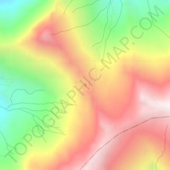
Name: Roopkund Lake topographic map, elevation, terrain.
Location: Roopkund Lake, Chamoli Tehsil, Chamoli, Uttarakhand, India (30.26174 79.73137 30.26249 79.73200)
Average elevation: 4,631 m
Minimum elevation: 3,974 m
Maximum elevation: 5,200 m
Make a donation
Other topographic maps
Click on a map to view its topography, its elevation and its terrain.
Gopeshwar
India > Uttarakhand > Chamoli Tehsil
Gopeshwar is located at 30°25′N 79°20′E / 30.42°N 79.33°E / 30.42; 79.33. It has an average elevation of 1,450 m (4,760 ft). Gopeshwar is 8.4 km (5.2 mi) away from Chamoli which is located on the banks of Alaknanda river and along NH 58. Gopeshwar is able to captivate any visitor with its…
Average elevation: 1,566 m
Make a donation
Gopeshwar
India > Uttarakhand > Chamoli Tehsil
Gopeshwar is located at 30°25′N 79°20′E / 30.42°N 79.33°E / 30.42; 79.33. It has an average elevation of 1,450 m (4,760 ft). Gopeshwar is 8.4 km (5.2 mi) away from Chamoli which is located on the banks of Alaknanda river and along NH 58.
Average elevation: 1,566 m