
Uva Province topographic map
Interactive map
Click on the map to display elevation.
About this map
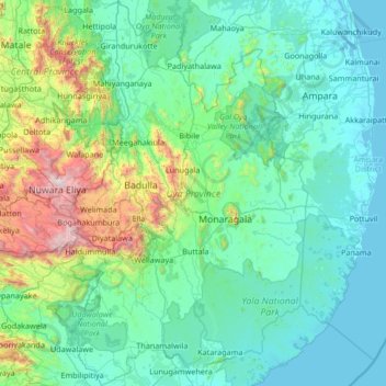
Name: Uva Province topographic map, elevation, terrain.
Location: Uva Province, Sri Lanka (6.29647 80.77594 7.62496 81.63715)
Average elevation: 327 m
Minimum elevation: -2 m
Maximum elevation: 2,493 m
Other topographic maps
Click on a map to view its topography, its elevation and its terrain.
Talawakele
Talawakelle (Sinhala: තලවාකැලේ, Tamil: தலவாக்கலை) is a town in Nuwara Eliya District in the Central Province, Sri Lanka, governed by an Urban Council. It is the centre of the Dimbula tea planting district, the largest tea growing area in Sri Lanka. It is situated on A7…
Average elevation: 1,363 m
Kotagala
Kotagala is a small town in the Nuwara Eliya District of the Central Province, Sri Lanka. It is located 35.8 km (22.2 mi) from Nuwara Eliya at an elevation of 1,247 m (4,091 ft) above sea level.
Average elevation: 1,327 m