
Ambagamuwa topographic map
Interactive map
Click on the map to display elevation.
About this map
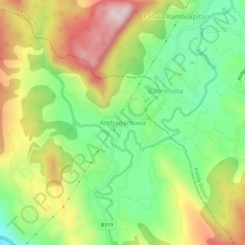
Name: Ambagamuwa topographic map, elevation, terrain.
Location: Ambagamuwa, Nuwara Eliya District, Central Province, Sri Lanka (6.99886 80.47303 7.03886 80.51303)
Average elevation: 679 m
Minimum elevation: 461 m
Maximum elevation: 966 m
Other topographic maps
Click on a map to view its topography, its elevation and its terrain.
upper division, north meddecombra
Sri Lanka > Central Province > upper division, north meddecombra
Average elevation: 1,268 m