
Thank you for supporting this site ❤️
Make a donation
Make a donation
Keppetipola topographic map
Click on the map to display elevation.
Thank you for supporting this site ❤️
Make a donation
Make a donation
About this map
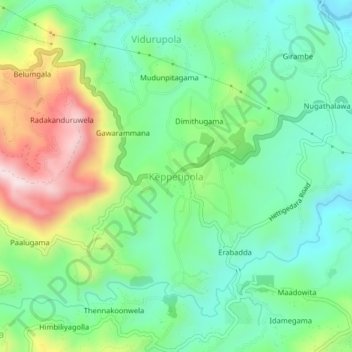
Name: Keppetipola topographic map, elevation, terrain.
Location: Keppetipola, Badulla District, Uva Province, 90350, Sri Lanka (6.87409 80.85019 6.91409 80.89019)
Average elevation: 1,205 m
Minimum elevation: 1,047 m
Maximum elevation: 1,529 m
Thank you for supporting this site ❤️
Make a donation
Make a donation
Other topographic maps
Click on a map to view its topography, its elevation and its terrain.