
Thank you for supporting this site ❤️
Make a donation
Make a donation
Pallegama topographic map
Click on the map to display elevation.
Thank you for supporting this site ❤️
Make a donation
Make a donation
About this map
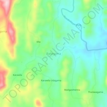
Name: Pallegama topographic map, elevation, terrain.
Location: Pallegama, Monaragala District, Uva Province, Sri Lanka (6.90947 81.24018 6.94947 81.28018)
Average elevation: 286 m
Minimum elevation: 203 m
Maximum elevation: 456 m
Thank you for supporting this site ❤️
Make a donation
Make a donation
Other topographic maps
Click on a map to view its topography, its elevation and its terrain.