
Thank you for supporting this site ❤️
Make a donation
Make a donation
Panwilathenna topographic map
Click on the map to display elevation.
Thank you for supporting this site ❤️
Make a donation
Make a donation
About this map
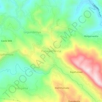
Name: Panwilathenna topographic map, elevation, terrain.
Average elevation: 813 m
Minimum elevation: 637 m
Maximum elevation: 1,094 m
Thank you for supporting this site ❤️
Make a donation
Make a donation
Other topographic maps
Click on a map to view its topography, its elevation and its terrain.
Thank you for supporting this site ❤️
Make a donation
Make a donation
upper division, north meddecombra
Sri Lanka > Central Province > upper division, north meddecombra
Average elevation: 1,268 m