
Thank you for supporting this site ❤️
Make a donation
Make a donation
Madagama topographic map
Click on the map to display elevation.
Thank you for supporting this site ❤️
Make a donation
Make a donation
About this map
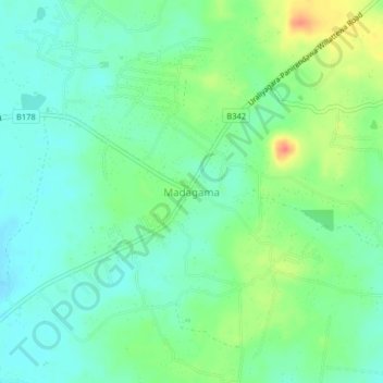
Name: Madagama topographic map, elevation, terrain.
Location: Madagama, Puttalam District, North Western Province, Sri Lanka (7.51319 79.85760 7.55319 79.89760)
Average elevation: 23 m
Minimum elevation: 6 m
Maximum elevation: 56 m
Thank you for supporting this site ❤️
Make a donation
Make a donation
Other topographic maps
Click on a map to view its topography, its elevation and its terrain.
Feeder Canal to Bathalagoda Lake from Daduru Oya Anicut
Sri Lanka > North Western Province > Kurunegala
Average elevation: 127 m