
Thank you for supporting this site ❤️
Make a donation
Make a donation
Panama topographic map
Click on the map to display elevation.
Thank you for supporting this site ❤️
Make a donation
Make a donation
About this map
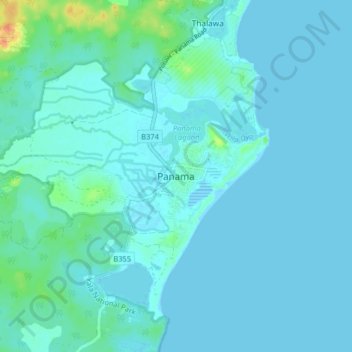
Name: Panama topographic map, elevation, terrain.
Location: Panama, Ampara District, Eastern Province, Sri Lanka (6.71673 81.76468 6.79673 81.84468)
Average elevation: 5 m
Minimum elevation: -1 m
Maximum elevation: 43 m
Thank you for supporting this site ❤️
Make a donation
Make a donation
Other topographic maps
Click on a map to view its topography, its elevation and its terrain.