
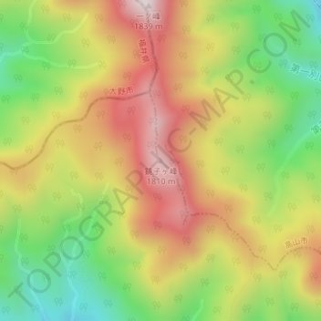
銚子ヶ峰 topographic map
Interactive map
Click on the map to display elevation.
About this map
Name: 銚子ヶ峰 topographic map, elevation, terrain.
Location: 銚子ヶ峰, 高山市, 岐阜県, 日本 (36.06184 136.76541 36.06194 136.76551)
Average elevation: 1,504 m
Minimum elevation: 1,187 m
Maximum elevation: 1,821 m
銚子ヶ峰(ちょうしがみね)は、岐阜県郡上市と高山市にまたがる、標高1,810 mの山。両白山地に属し、続ぎふ百山に選定されている。
Other topographic maps
Click on a map to view its topography, its elevation and its terrain.