
Bhutan topographic map
Interactive map
Click on the map to display elevation.
About this map
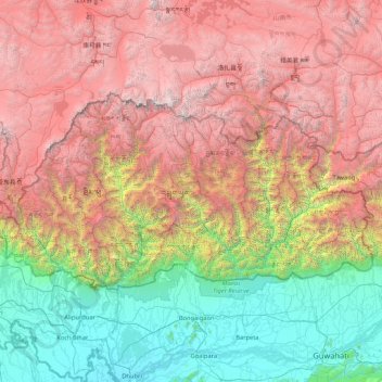
Name: Bhutan topographic map, elevation, terrain.
Location: Bhutan (26.70169 88.74649 28.24742 92.12523)
Average elevation: 2,736 m
Minimum elevation: 24 m
Maximum elevation: 7,385 m
Bhutan is on the southern slopes of the eastern Himalayas, landlocked between the Tibet Autonomous Region of China to the north and the Indian states of Sikkim, West Bengal, Assam to the west and south, and the Indian state of Arunachal Pradesh to the east. It lies between latitudes 26°N and 29°N, and longitudes 88°E and 93°E. The land consists mostly of steep and high mountains crisscrossed by a network of swift rivers that form deep valleys before draining into the Indian plains. Elevation rises from 200 m (660 ft) in the southern foothills to more than 7,000 m (23,000 ft). This great geographical diversity combined with equally diverse climate conditions contributes to Bhutan's outstanding range of biodiversity and ecosystems.
Other topographic maps
Click on a map to view its topography, its elevation and its terrain.
Montreal
Canada > Quebec > Urban agglomeration of Montreal > Montreal
Montreal, Urban agglomeration of Montreal, Montreal (06), Quebec, H3B 1M7, Canada
Average elevation: 30 m
Hyderabad
India > Telangana > Bahadurpura mandal
Hyderabad, Bahadurpura mandal, Hyderabad District, Telangana, India
Average elevation: 549 m
Sri Lanka
Sri Lanka
Average elevation: 50 m
Delhi
India > Delhi > Kotwali Tehsil
Delhi, Kotwali Tehsil, Central Delhi, Delhi, 110006, India
Average elevation: 216 m
Snohomish County
Snohomish County, Washington, United States
Average elevation: 649 m
India
India
Average elevation: 1,017 m
Bhuntar
Bhuntar, Kullu District, Himachal Pradesh, India
Average elevation: 3,873 m
Bengaluru
India > Karnataka > Bangalore North
Bengaluru, Bangalore North, Bengaluru Urban District, Karnataka, India
Average elevation: 881 m
Grants Pass
United States > Oregon > Josephine County
Grants Pass, Josephine County, Oregon, United States
Average elevation: 377 m
Devanahalli
India > Karnataka > Devanahalli taluk
Devanahalli, Devanahalli taluk, Bengaluru Rural District, Karnataka, 562110, India
Average elevation: 900 m
Bhopal
India > Madhya Pradesh > Huzur Tahsil
Bhopal, Huzur Tahsil, Bhopal District, Madhya Pradesh, 462001, India
Average elevation: 498 m
Jhimar
India > Uttarakhand > Molekhal
Jhimar, Molekhal, Almora District, Uttarakhand, India
Average elevation: 1,663 m
Navi Mumbai
India > Maharashtra > Thane > Navi Mumbai
Navi Mumbai, Mumbai Metropolitan Region, Thane, Maharashtra, 400706, India
Average elevation: 30 m
Lingoda
India > Madhya Pradesh > Agar Tahsil
Lingoda, Agar Tahsil, Agar Malwa District, Madhya Pradesh, India
Average elevation: 478 m
Thalai Nagar
India > Tamil Nadu > Veppanthattai > Thaluthalai
Thalai Nagar, Thaluthalai, Veppanthattai, Perambalur District, Tamil Nadu, 621103, India
Average elevation: 146 m
Anaikatti
India > Tamil Nadu > Coimbatore North
Anaikatti, Mannarkad, Palakkad District, Kerala, 678741, India
Average elevation: 623 m
Sanghi
Sanghi, North Gondar, Amhara Region, Ethiopia
Average elevation: 1,181 m
Kandy
Kandy, Kandy District, Central Province, 20000, Sri Lanka
Average elevation: 621 m
Pune
India > Maharashtra > Pune City > Pune
Pune, Pune City, Pune District, Maharashtra, 411001, India
Average elevation: 641 m
Parasia
India > Madhya Pradesh > Parasia Tahsil > Parasia
Parasia, Parasia Tahsil, Chhindwara District, Madhya Pradesh, 480441, India
Average elevation: 786 m
Ulapane
Ulapane, Kandy District, Central Province, 20668, Sri Lanka
Average elevation: 670 m
Jamunia
India > Madhya Pradesh > Gairatganj Tahsil
Jamunia, Gairatganj Tahsil, Raisen District, Madhya Pradesh, India
Average elevation: 559 m
Ocheretyne
Ocheretyne, Ocheretyne settlement hromada, Pokrovskii Raion, Donetsk Oblast, 86020, Ukraine
Average elevation: 227 m
Kanyakumari district
Kanyakumari district, Tamil Nadu, India
Average elevation: 226 m
Ooty Lake
India > Tamil Nadu > Udhagamandalam > Udhagamandalam
Ooty Lake, Udhagamandalam, The Nilgiris District, Tamil Nadu, 643001, India
Average elevation: 2,235 m
Panvel
India > Maharashtra > Panvel > Panvel
Panvel, Raigad, Maharashtra, 410206, India
Average elevation: 75 m
Barkuru
India > Karnataka > Brahmavara taluku
Barkuru, Brahmavara taluku, Udupi District, Karnataka, 576210, India
Average elevation: 13 m
Agency Lake
United States > Oregon > Klamath County
Agency Lake, Klamath County, Oregon, United States
Average elevation: 1,266 m
Bagnoli
Italy > Campania > Benevento > Sant'Agata de' Goti
Bagnoli, Sant'Agata de' Goti, Benevento, Campania, 82015, Italy
Average elevation: 203 m
Dharamshala
India > Himachal Pradesh > Dharamshala
Dharamshala, Kangra District, Himachal Pradesh, 176200, India
Average elevation: 1,781 m
Chennai
India > Tamil Nadu > Chennai
Chennai, Chennai District, Tamil Nadu, India
Average elevation: 8 m
Thiruvananthapuram
India > Kerala > Thiruvananthapuram
Thiruvananthapuram, Thiruvananthapuram District, Kerala, 695001, India
Average elevation: 33 m
Colombo
Colombo, Colombo District, Western Province, Sri Lanka
Average elevation: 5 m
Siliguri
India > West Bengal > Siliguri Subdivsion
Siliguri, Siliguri Subdivsion, Darjeeling District, West Bengal, India
Average elevation: 121 m
Vadodara
India > Gujarat > Vadodara Taluka
Vadodara, Vadodara Taluka, Vadodara District, Gujarat, 390001, India
Average elevation: 36 m
Surat
India > Gujarat > Katargam Taluka > Surat
Surat, Katargam Taluka, Surat, Gujarat, 395001, India
Average elevation: 11 m