
Make a donation
1089 topographic map
Click on the map to display elevation.
Make a donation
About this map
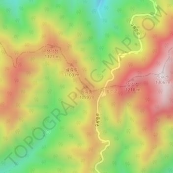
Name: 1089 topographic map, elevation, terrain.
Location: 1089, Yangyang-gun, Gangwon-do, South Korea (37.88070 128.51115 37.88080 128.51125)
Average elevation: 943 m
Minimum elevation: 585 m
Maximum elevation: 1,283 m
Make a donation
Other topographic maps
Click on a map to view its topography, its elevation and its terrain.
Make a donation
Make a donation
Seodaemun-gu
Seodaemun District incorporates residential areas and historical areas including Bongwon Temple, Sinchon Railway Station (the oldest train station in Seoul) and Seodaemun Prison History Hall. Also it has a historic culture site "Seodaemun Independence Park." This place located at Dongnimmun station, includes a…
Average elevation: 70 m
Yongsan-gu
Yongsan is located next to the Han River, with level ground in the west of the district which has been used for transportation (rail) and commercial use since the early 20th century. To the east and north in the land is steeper and rises towards Namsan which lies to the north. Namsan has an elevation of 243m…
Average elevation: 39 m
Make a donation
Make a donation
Make a donation
Jeju Island
The island is home to 660,000 people, but hosts 15,000,000 visitors per year. English is not widely spoken in Jeju, and as a matter of fact, “the local dialect is different enough from Korean that it is recognized as a distinct language.” “Until recently, Chinese travelers accounted for 80% of foreign…
Average elevation: 98 m
Make a donation
Make a donation
South Chungcheong
At 845 metres, Mount Gyeryong is the most notable elevation. It is located in a national park which is noted for its unique rock features. Apart from the stone formations there are a number of old temples. These include Gwanchok-sa, a temple which is home to the largest stone Buddha in Korea. In 1978 the Taean…
Average elevation: 89 m
Gyeonggi
The topography of Gyeonggi-do is divided into southern and northern areas by the Han River, which flows from east to west. The area north to the Han River is mainly mountainous, while the southern area is mainly plain.
Average elevation: 136 m
Make a donation