
Thank you for supporting this site ❤️
Make a donation
Make a donation
Gangwon topographic map
Click on the map to display elevation.
Thank you for supporting this site ❤️
Make a donation
Make a donation
About this map
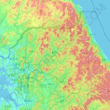
Name: Gangwon topographic map, elevation, terrain.
Location: Gangwon, South Korea (37.02783 127.09594 38.62033 129.62438)
Average elevation: 314 m
Minimum elevation: -2 m
Maximum elevation: 1,656 m
Thank you for supporting this site ❤️
Make a donation
Make a donation
Other topographic maps
Click on a map to view its topography, its elevation and its terrain.