
Thank you for supporting this site ❤️
Make a donation
Make a donation
Busan topographic map
Click on the map to display elevation.
Thank you for supporting this site ❤️
Make a donation
Make a donation
About this map
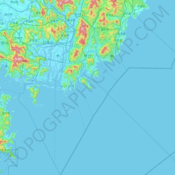
Name: Busan topographic map, elevation, terrain.
Location: Busan, South Korea (34.72525 128.75681 35.38922 129.48895)
Average elevation: 40 m
Minimum elevation: -5 m
Maximum elevation: 770 m
Thank you for supporting this site ❤️
Make a donation
Make a donation
Other topographic maps
Click on a map to view its topography, its elevation and its terrain.