
Thank you for supporting this site ❤️
Make a donation
Make a donation
North Gyeongsang topographic map
Click on the map to display elevation.
Thank you for supporting this site ❤️
Make a donation
Make a donation
About this map
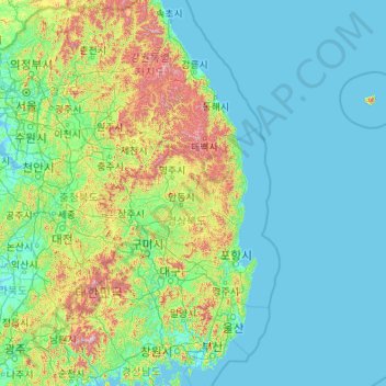
Name: North Gyeongsang topographic map, elevation, terrain.
Location: North Gyeongsang, South Korea (35.56638 127.79642 37.75337 132.14678)
Average elevation: 166 m
Minimum elevation: -2 m
Maximum elevation: 1,693 m
Thank you for supporting this site ❤️
Make a donation
Make a donation
Other topographic maps
Click on a map to view its topography, its elevation and its terrain.