
Seodaemun-gu topographic map
Interactive map
Click on the map to display elevation.
Seodaemun-gu
Seodaemun District incorporates residential areas and historical areas including Bongwon Temple, Sinchon Railway Station (the oldest train station in Seoul) and Seodaemun Prison History Hall. Also it has a historic culture site "Seodaemun Independence Park." This place located at Dongnimmun station, includes a 3.1 independence memorial statue, Independence Gate and more. This educational park is a major tourist attraction of Seodaemun District. Seodaemun District is a Rest Place together with nature surrounded by Mt. Ansan, Mt. Baengnyeonsan and Hongjecheon stream in the city. Also known as Mt. Muaksan, Mt. Ansan has many steep slopes, but because it has an altitude of only 295.5m, it is a favorite hiking trail among locals. There are about ten climbing courses. At the summit, there is Ansan Beacon Mound, with views of Mt. Bukhansan, Mt. Inwangsan, Haegjusanseong Fortress and Hangang River. Mt. Ansan is a highly popular tourist attraction of Seodaemun District. Also, on the Mt. Ansan path, the Seodaemun Museum of Natural History, built by the local governing body, exhibits various geological and biological relics and records. Named after Hongjewon, which was where Chinese envoys were greet and entertained, Hongjecheon Stream was where the women who were forcefully taken to the Qing Dynasty cleansed their bodies upon returning home. The once dried stream was restored and today there is a musical fountain, a water mill, a man-made waterfall and hiking trails.
About this map
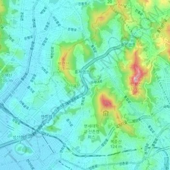
Name: Seodaemun-gu topographic map, elevation, terrain.
Location: Seodaemun-gu, Seoul, South Korea (37.55510 126.90195 37.61075 126.96947)
Average elevation: 70 m
Minimum elevation: 12 m
Maximum elevation: 325 m
Other topographic maps
Click on a map to view its topography, its elevation and its terrain.