
Thank you for supporting this site ❤️
Make a donation
Make a donation
Sejong topographic map
Click on the map to display elevation.
Thank you for supporting this site ❤️
Make a donation
Make a donation
About this map
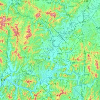
Name: Sejong topographic map, elevation, terrain.
Location: Sejong, South Korea (36.40679 127.12752 36.73379 127.41115)
Average elevation: 97 m
Minimum elevation: 4 m
Maximum elevation: 438 m
Thank you for supporting this site ❤️
Make a donation
Make a donation
Other topographic maps
Click on a map to view its topography, its elevation and its terrain.