
Suwon-si topographic map
Interactive map
Click on the map to display elevation.
About this map
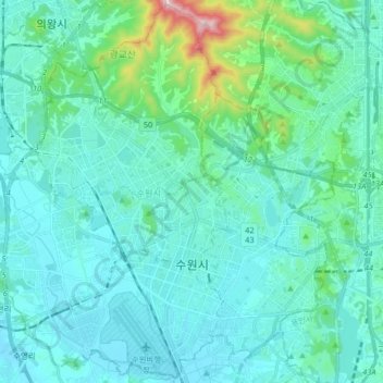
Name: Suwon-si topographic map, elevation, terrain.
Location: Suwon-si, Gyeonggi, South Korea (37.22453 126.92697 37.35105 127.08987)
Average elevation: 88 m
Minimum elevation: 16 m
Maximum elevation: 554 m
Since 2013, Suwon has been home to KT Wiz. The team played at Sungkyunkwan University till Suwon Baseball Stadium remodelling was completed in time for their elevation to the KBO League in 2015. The stadium was previously the home of the Hyundai Unicorns, but this team folded after the 2007 season.
Other topographic maps
Click on a map to view its topography, its elevation and its terrain.
Austrailia Pavilion
Austrailia Pavilion, Makgye-dong, Gwacheon-si, Gyeonggi, South Korea
Average elevation: 144 m
24228
24228, Chuncheon-si, Gangwon State, South Korea
Average elevation: 85 m
16037
16037, Naeson 1-dong, Uiwang-si, Gyeonggi, South Korea
Average elevation: 98 m
Yeongtong-gu
Yeongtong-gu, Suwon-si, Gyeonggi, South Korea
Average elevation: 72 m
Daebeop-ri
Daebeop-ri, Goseong-gun, South Gyeongsang, 52906, South Korea
Average elevation: 180 m
Bundang-gu
Bundang-gu, Seongnam-si, Gyeonggi, South Korea
Average elevation: 147 m
Goesan-eup
Goesan-eup, Goesan-gun, North Chungcheong, South Korea
Average elevation: 182 m
Yangnim-dong
Yangnim-dong, Nam-gu, Gwangju, 61662, South Korea
Average elevation: 62 m
Heungdeok-gu
Heungdeok-gu, Cheongju-si, North Chungcheong, South Korea
Average elevation: 74 m
Deogyang-gu
Deogyang-gu, Goyang-si, Gyeonggi, 10497, South Korea
Average elevation: 23 m
Amsa-dong Prehistoric Settlement Site
Amsa-dong Prehistoric Settlement Site, 875, Amsa 2(i)-dong, Gangdong-gu, Seoul, South Korea
Average elevation: 24 m
Hwagae-myeon
Hwagae-myeon, Hadong-gun, South Gyeongsang, 52303, South Korea
Average elevation: 657 m
Nam-gu
Nam-gu, Pohang-si, North Gyeongsang, South Korea
Average elevation: 97 m
Ssangji-ri
Ssangji-ri, Suncheon-si, South Jeolla, 57919, South Korea
Average elevation: 180 m
Bugam-ri
Bugam-ri, Boeun-gun, North Chungcheong, 28910, South Korea
Average elevation: 409 m
Hoamsan Mountain
Hoamsan Mountain, Yeosu-si, South Jeolla, 59629, South Korea
Average elevation: 99 m
Hajang-myeon
Hajang-myeon, Samcheok-si, Gangwon State, South Korea
Average elevation: 772 m
Ulleungdo Island
South Korea > Ulleung-gun > Dodong-ri
Ulleungdo Island, Dodong-ri, Ulleung-gun, North Gyeongsang, South Korea
Average elevation: 189 m
Seattle Park
Seattle Park, Dunsan-dong, Dunsan 1(il)-dong, Seo-gu, Daejeon, South Korea
Average elevation: 51 m
Gapyeong
Gapyeong, Gapyeong-gun, Gyeonggi, 12419, South Korea
Average elevation: 157 m