
Seattle Park topographic map
Interactive map
Click on the map to display elevation.
About this map
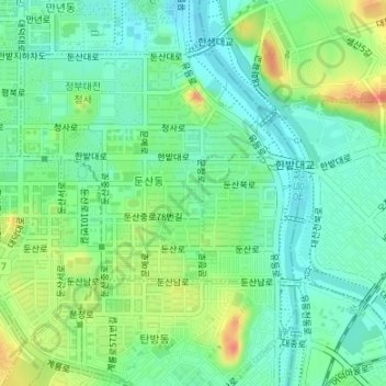
Name: Seattle Park topographic map, elevation, terrain.
Average elevation: 51 m
Minimum elevation: 33 m
Maximum elevation: 85 m
Other topographic maps
Click on a map to view its topography, its elevation and its terrain.
Sinseong-dong
Sinseong-dong, Yuseong-gu, Daejeon, South Korea
Average elevation: 111 m
Jayang-dong
South Korea > Daejeon > Jayang-dong
Jayang-dong, Dong-gu, Daejeon, South Korea
Average elevation: 96 m
Hyo-dong
South Korea > Daejeon > Hyo-dong
Hyo-dong, Dong-gu, Daejeon, South Korea
Average elevation: 109 m