
Deogyang-gu topographic map
Interactive map
Click on the map to display elevation.
About this map
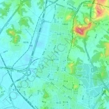
Name: Deogyang-gu topographic map, elevation, terrain.
Location: Deogyang-gu, Goyang-si, Gyeonggi, 10497, South Korea (37.61690 126.81220 37.65690 126.85220)
Average elevation: 23 m
Minimum elevation: 2 m
Maximum elevation: 102 m
Other topographic maps
Click on a map to view its topography, its elevation and its terrain.
Deogyang-gu
Deogyang-gu, Goyang-si, Gyeonggi, South Korea
Average elevation: 49 m
Hyoja-dong
South Korea > Goyang-si > Hyoja-dong
Hyoja-dong, Deogyang-gu, Goyang-si, Gyeonggi, South Korea
Average elevation: 233 m