
Dongnae-gu topographic map
Interactive map
Click on the map to display elevation.
About this map
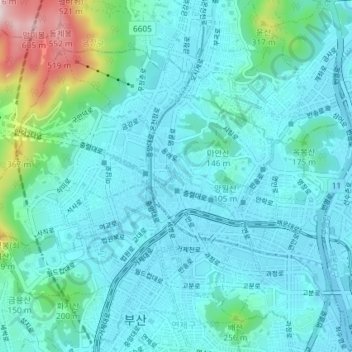
Name: Dongnae-gu topographic map, elevation, terrain.
Location: Dongnae-gu, Busan, South Korea (35.18268 129.04342 35.22588 129.11645)
Average elevation: 87 m
Minimum elevation: 0 m
Maximum elevation: 600 m
Other topographic maps
Click on a map to view its topography, its elevation and its terrain.
Munhyeon-dong
South Korea > Busan > Munhyeon-dong
Munhyeon-dong, Nam-gu, Busan, South Korea
Average elevation: 50 m
Sajik-dong
South Korea > Busan > Sajik-dong
Sajik-dong, Dongnae-gu, Busan, South Korea
Average elevation: 70 m
Daeyeon-dong
South Korea > Busan > Daeyeon-dong
Daeyeon-dong, Nam-gu, Busan, South Korea
Average elevation: 71 m
Namsan-dong
South Korea > Busan > Namsan-dong
Namsan-dong, Geumjeong-gu, Busan, South Korea
Average elevation: 135 m