
Thank you for supporting this site ❤️
Make a donation
Make a donation
Gunsan-si topographic map
Click on the map to display elevation.
Thank you for supporting this site ❤️
Make a donation
Make a donation
About this map
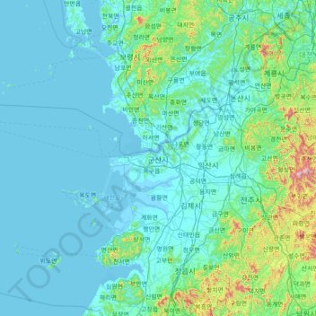
Name: Gunsan-si topographic map, elevation, terrain.
Location: Gunsan-si, Jeonbuk State, South Korea (35.66162 125.52337 36.27821 126.91535)
Average elevation: 85 m
Minimum elevation: -2 m
Maximum elevation: 1,061 m
Thank you for supporting this site ❤️
Make a donation
Make a donation
Other topographic maps
Click on a map to view its topography, its elevation and its terrain.
Thank you for supporting this site ❤️
Make a donation
Make a donation
Thank you for supporting this site ❤️
Make a donation
Make a donation
Hallasan
The occurrence of the highest temperature coincides with the formation position of the eddy, and when the wind is weak, the eddy forms in the middle mountain region. When the wind is weak, the warmth is accumulated in the middle layer, so the maximum temperature in the mid-mountainous area is higher than the…
Average elevation: 1,652 m
Thank you for supporting this site ❤️
Make a donation
Make a donation
Thank you for supporting this site ❤️
Make a donation
Make a donation
Thank you for supporting this site ❤️
Make a donation
Make a donation
Thank you for supporting this site ❤️
Make a donation
Make a donation
Thank you for supporting this site ❤️
Make a donation
Make a donation
Thank you for supporting this site ❤️
Make a donation
Make a donation
Thank you for supporting this site ❤️
Make a donation
Make a donation
Thank you for supporting this site ❤️
Make a donation
Make a donation