
Philippinen topographic map
Interactive map
Click on the map to display elevation.
About this map
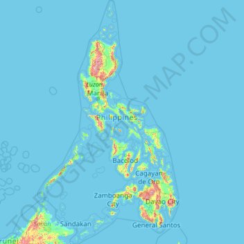
Name: Philippinen topographic map, elevation, terrain.
Location: Philippinen (4.21581 114.10369 21.32178 126.80726)
Average elevation: 34 m
Minimum elevation: -1 m
Maximum elevation: 2,546 m
Das Klima der Philippinen wird vor allem durch die Nähe zum Meer geprägt, denn kein Ort ist weiter als 200 km von der Küste entfernt. Das Klima der Philippinen lässt sich als zumeist tropisch und in den höheren Lagen der Gebirge als subtropisch bezeichnen. Am Berg Pulag fällt in den kalten Jahreszeiten gelegentlich sogar Schnee. Die durchschnittliche Jahrestemperatur auf den Philippinen wird mit 26,5 °C angegeben. Die Effektive Klimaklassifikation der Philippinen wird in dem von Wladimir Peter Köppen entwickelten System als Tropische Klimate charakterisiert.
Other topographic maps
Click on a map to view its topography, its elevation and its terrain.
Montreal
Canada > Quebec > Urban agglomeration of Montreal > Montreal
Montreal, Urban agglomeration of Montreal, Montreal (06), Quebec, H3B 1M7, Canada
Average elevation: 30 m
India
India
Average elevation: 1,017 m
Hyderabad
India > Telangana > Bahadurpura mandal
Hyderabad, Bahadurpura mandal, Hyderabad District, Telangana, India
Average elevation: 549 m
Haywood County
United States > North Carolina
Haywood County, North Carolina, United States
Average elevation: 1,044 m
Snohomish County
Snohomish County, Washington, United States
Average elevation: 649 m
Haraluru
India > Karnataka > Tumkur taluk
Haraluru, Tumkur taluk, Tumakuru District, Karnataka, India
Average elevation: 864 m
Ocheretyne
Ocheretyne, Ocheretyne settlement hromada, Pokrovskii Raion, Donetsk Oblast, 86020, Ukraine
Average elevation: 227 m
Tacoma
United States > Washington > Pierce County
Tacoma, Pierce County, Washington, United States
Average elevation: 67 m
Chennai
India > Tamil Nadu > Chennai
Chennai, Chennai District, Tamil Nadu, India
Average elevation: 8 m
Sri Lanka
Sri Lanka
Average elevation: 50 m
city de boutet de monvel (ethanlecartographe
France > Grand Est > Meurthe-et-Moselle > Lunéville
city de boutet de monvel (ethanlecartographe, Lunéville, Meurthe-et-Moselle, Grand Est, Metropolitan France, 54300, France
Average elevation: 240 m
Mangaluru
India > Karnataka > Mangaluru taluk
Mangaluru, Mangaluru taluk, Dakshina Kannada District, Karnataka, 575001, India
Average elevation: 25 m
Bengaluru
India > Karnataka > Bangalore North
Bengaluru, Bangalore North, Bengaluru Urban District, Karnataka, India
Average elevation: 881 m
Noida
India > Uttar Pradesh > Dadri
Noida, Dadri, Gautam Buddha Nagar District, Uttar Pradesh, 201301, India
Average elevation: 216 m
Pune
India > Maharashtra > Pune City > Pune
Pune, Pune City, Pune District, Maharashtra, 411001, India
Average elevation: 641 m
Nepal
Nepal
Average elevation: 2,604 m
Ruang
Indonesia > North Sulawesi > Kepulauan Siau Tagulandang Biaro > Pumpente
Ruang, Pumpente, Kepulauan Siau Tagulandang Biaro, North Sulawesi, Sulawesi, Indonesia
Average elevation: 274 m
Melbourne Water Pipe Reserve
Australia > Victoria > Melbourne
Melbourne Water Pipe Reserve, Burwood East, Melbourne, City of Whitehorse, Victoria, Australia
Average elevation: 119 m
Shangaime
Ecuador > Morona Santiago > Huamboya
Shangaime, Chiguaza, Huamboya, Morona Santiago, Ecuador
Average elevation: 810 m
Kadthal
India > Telangana > Soan mandal
Kadthal, Soan mandal, Nirmal District, Telangana, 504105, India
Average elevation: 318 m
Delhi
India > Delhi > Kotwali Tehsil
Delhi, Kotwali Tehsil, Central Delhi, Delhi, 110006, India
Average elevation: 216 m
Madurai
India > Tamil Nadu > Madurai
Madurai, Madurai South, Madurai district, Tamil Nadu, India
Average elevation: 138 m
Fojnica
Bosnia and Herzegovina > Federation of Bosnia and Herzegovina
Fojnica, Fojnica municipality, Central Bosnia Canton, Federation of Bosnia and Herzegovina, 71270, Bosnia and Herzegovina
Average elevation: 932 m
Malham
United Kingdom > England > North Yorkshire
Malham, North Yorkshire, England, United Kingdom
Average elevation: 371 m
Dambadeniya
Sri Lanka > North Western Province
Dambadeniya, Kurunegala District, North Western Province, 60130, Sri Lanka
Average elevation: 64 m
Kovilanchery
India > Tamil Nadu > Tambaram
Kovilanchery, Tambaram, Chengalpattu District, Tamil Nadu, 600126, India
Average elevation: 11 m
Pedda Arikatla
India > Andhra Pradesh > Konakanamitla
Pedda Arikatla, Konakanamitla, Prakasam, Andhra Pradesh, 523245, India
Average elevation: 119 m
Mandi
India > Himachal Pradesh > Mandi
Mandi, Mandi District, Himachal Pradesh, 175001, India
Average elevation: 1,273 m
Anaikatti
India > Tamil Nadu > Coimbatore North
Anaikatti, Mannarkad, Palakkad District, Kerala, 678741, India
Average elevation: 623 m
Ooty Lake
India > Tamil Nadu > Udhagamandalam > Udhagamandalam
Ooty Lake, Udhagamandalam, The Nilgiris District, Tamil Nadu, 643001, India
Average elevation: 2,235 m
Tutu Karue
Tutu Karue, Sigi Regency, Central Sulawesi, Sulawesi, Indonesia
Average elevation: 831 m
Bhikangaon
India > Madhya Pradesh > Bhikangaon Tahsil
Bhikangaon, Bhikangaon Tahsil, Khargone District, Madhya Pradesh, India
Average elevation: 299 m
Chasiv Yar
Chasiv Yar, Chasiv Yar urban hromada, Bakhmut Raion, Donetsk Oblast, 84551-84556, Ukraine
Average elevation: 213 m