
Saudi Arabia topographic map
Interactive map
Click on the map to display elevation.
About this map
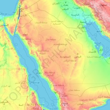
Name: Saudi Arabia topographic map, elevation, terrain.
Location: Saudi Arabia (16.29000 34.45717 32.15428 55.66669)
Average elevation: 551 m
Minimum elevation: -415 m
Maximum elevation: 3,894 m
Saudi Arabia's diverse geography is dominated by the Arabian Desert, associated semi-desert, shrubland, steppes, several mountain ranges, volcanic lava fields and highlands. The 647,500 km2 (250,001 sq mi) Rub' al Khali ("Empty Quarter") in the southeastern part of the country is the world's largest contiguous sand desert. Though there are lakes in the country, Saudi Arabia is the largest country in the world by area with no permanent rivers. Wadis, non-permanent rivers, however, are very numerous. The fertile areas are to be found in the alluvial deposits in wadis, basins, and oases. The main topographical feature is the central plateau which rises abruptly from the Red Sea and gradually descends into the Nejd and toward the Persian Gulf. On the Red Sea coast, there is a narrow coastal plain, known as the Tihamah parallel to which runs an imposing escarpment. The southwest province of Asir is mountainous, and contains the 3,133 m (10,279 ft) Mount Sawda, which is the highest point in the country. Saudi Arabia is home to more than 2000 dormant volcanoes. Lava fields in Hejaz, known locally by their Arabic name of harrat (the singular is harrah), form one of Earth's largest alkali basalt regions, covering some 180,000 square kilometres (69,000 sq mi), an area greater than the state of Missouri.
Other topographic maps
Click on a map to view its topography, its elevation and its terrain.
Montreal
Canada > Quebec > Urban agglomeration of Montreal > Montreal
Montreal, Urban agglomeration of Montreal, Montreal (06), Quebec, H3B 1M7, Canada
Average elevation: 30 m
India
India
Average elevation: 1,017 m
Sri Lanka
Sri Lanka
Average elevation: 50 m
Hyderabad
India > Telangana > Bahadurpura mandal
Hyderabad, Bahadurpura mandal, Hyderabad District, Telangana, India
Average elevation: 549 m
Snohomish County
Snohomish County, Washington, United States
Average elevation: 649 m
Navi Mumbai
India > Maharashtra > Thane > Navi Mumbai
Navi Mumbai, Mumbai Metropolitan Region, Thane, Maharashtra, 400706, India
Average elevation: 30 m
Anaikatti
India > Tamil Nadu > Coimbatore North
Anaikatti, Mannarkad, Palakkad District, Kerala, 678741, India
Average elevation: 623 m
Jhimar
India > Uttarakhand > Molekhal
Jhimar, Molekhal, Almora District, Uttarakhand, India
Average elevation: 1,663 m
Bengaluru
India > Karnataka > Bangalore North
Bengaluru, Bangalore North, Bengaluru Urban District, Karnataka, India
Average elevation: 881 m
Colombo
Colombo, Colombo District, Western Province, Sri Lanka
Average elevation: 5 m
Thalai Nagar
India > Tamil Nadu > Veppanthattai > Thaluthalai
Thalai Nagar, Thaluthalai, Veppanthattai, Perambalur District, Tamil Nadu, 621103, India
Average elevation: 146 m
Sanghi
Sanghi, North Gondar, Amhara Region, Ethiopia
Average elevation: 1,181 m
Barkuru
India > Karnataka > Brahmavara taluku
Barkuru, Brahmavara taluku, Udupi District, Karnataka, 576210, India
Average elevation: 13 m
Agency Lake
United States > Oregon > Klamath County
Agency Lake, Klamath County, Oregon, United States
Average elevation: 1,266 m
Bagnoli
Italy > Campania > Benevento > Sant'Agata de' Goti
Bagnoli, Sant'Agata de' Goti, Benevento, Campania, 82015, Italy
Average elevation: 203 m
Vadodara
India > Gujarat > Vadodara Taluka
Vadodara, Vadodara Taluka, Vadodara District, Gujarat, 390001, India
Average elevation: 36 m
Surat
India > Gujarat > Katargam Taluka > Surat
Surat, Katargam Taluka, Surat, Gujarat, 395001, India
Average elevation: 11 m
Pune
India > Maharashtra > Pune City > Pune
Pune, Pune City, Pune District, Maharashtra, 411001, India
Average elevation: 641 m
Nepal
Nepal
Average elevation: 2,604 m
Ragala
Ragala, Nuwara Eliya District, Central Province, Sri Lanka
Average elevation: 1,632 m
Udapussellawa
Udapussellawa, Nuwara Eliya District, Central Province, Sri Lanka
Average elevation: 1,254 m
Musi River
Musi River, Hyderabad, Uppal mandal, Medchal–Malkajgiri, Telangana, 5000036, India
Average elevation: 490 m
Dharamshala
India > Himachal Pradesh > Dharamshala
Dharamshala, Kangra District, Himachal Pradesh, 176200, India
Average elevation: 1,781 m
Thiruvananthapuram
India > Kerala > Thiruvananthapuram
Thiruvananthapuram, Thiruvananthapuram District, Kerala, 695001, India
Average elevation: 33 m
Oktwin Township
Oktwin Township, Taungoo District, East Bago Region, Bago Region, 08121, Myanmar
Average elevation: 150 m
Devanahalli
India > Karnataka > Devanahalli taluk
Devanahalli, Devanahalli taluk, Bengaluru Rural District, Karnataka, 562110, India
Average elevation: 900 m
Kandy
Kandy, Kandy District, Central Province, 20000, Sri Lanka
Average elevation: 621 m
Tacoma
United States > Washington > Pierce County
Tacoma, Pierce County, Washington, United States
Average elevation: 67 m
Haywood County
United States > North Carolina
Haywood County, North Carolina, United States
Average elevation: 1,044 m
Delhi
India > Delhi > Kotwali Tehsil
Delhi, Kotwali Tehsil, Central Delhi, Delhi, 110006, India
Average elevation: 216 m
Bhopal
India > Madhya Pradesh > Huzur Tahsil
Bhopal, Huzur Tahsil, Bhopal District, Madhya Pradesh, 462001, India
Average elevation: 498 m
Nanuoya Wood Shop
Sri Lanka > Central Province > Embilmeegama
Nanuoya Wood Shop, Kiribathkumbura, Embilmeegama, Kandy District, Central Province, 20450, Sri Lanka
Average elevation: 522 m
Hatan
India > Rajasthan > Asind Tehsil
Hatan, Asind Tehsil, Bhilwara District, Rajasthan, 311204, India
Average elevation: 462 m
Chennimalai
India > Tamil Nadu > Perundurai
Chennimalai, Perundurai, Erode District, Tamil Nadu, 638051, India
Average elevation: 267 m