
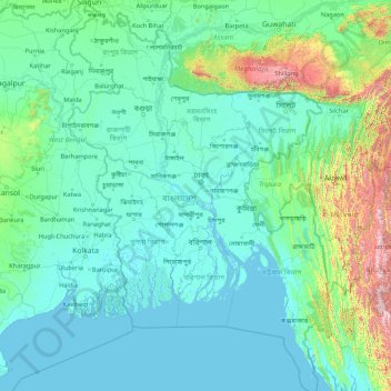
Bangladesh topographic map
Interactive map
Click on the map to display elevation.
About this map
Name: Bangladesh topographic map, elevation, terrain.
Location: Bangladesh (20.36791 88.00792 26.63825 92.68030)
Average elevation: 161 m
Minimum elevation: -2 m
Maximum elevation: 2,636 m
Bangladesh is predominantly rich fertile flat land. Most of it is less than 12 m (39 ft) above sea level, and it is estimated that about 10% of its land would be flooded if the sea level were to rise by 1 m (3.3 ft). 17% of the country is covered by forests and 12% is covered by hill systems. The country's haor wetlands are of significance to global environmental science. The highest point in Bangladesh is the Saka Haphong, located near the border with Myanmar, with an elevation of 1,064 m (3,491 ft). Previously, either Keokradong or Tazing Dong were considered the highest.
Other topographic maps
Click on a map to view its topography, its elevation and its terrain.
India
India
Average elevation: 1,017 m
Sri Lanka
Sri Lanka
Average elevation: 50 m
Hyderabad
India > Telangana > Bahadurpura mandal
Hyderabad, Bahadurpura mandal, Hyderabad District, Telangana, India
Average elevation: 549 m
Montreal
Canada > Quebec > Urban agglomeration of Montreal > Montreal
Montreal, Urban agglomeration of Montreal, Montreal (06), Quebec, H3B 1M7, Canada
Average elevation: 30 m
Nepal
Nepal
Average elevation: 2,604 m
Vadodara
India > Gujarat > Vadodara Taluka
Vadodara, Vadodara Taluka, Vadodara District, Gujarat, 390001, India
Average elevation: 36 m
Kannamedi
India > Karnataka > Pavagada taluk
Kannamedi, Pavagada taluk, Tumakuru District, Karnataka, India
Average elevation: 708 m
Hariharapura
India > Karnataka > Koppa taluk
Hariharapura, Koppa taluk, Chikkamagaluru District, Karnataka, 577120, India
Average elevation: 648 m
Pullalarevu
India > Andhra Pradesh > Raptadu
Pullalarevu, Raptadu, Anantapur, Andhra Pradesh, 515722, India
Average elevation: 389 m
Mambakkam
India > Tamil Nadu > Tiruporur
Mambakkam, Tiruporur, Chengalpattu District, Tamil Nadu, 600127, India
Average elevation: 16 m
A`zaz
A`zaz, Azaz Subdistrict, Azaz District, Aleppo Governorate, Syria
Average elevation: 559 m
Ocheretyne
Ocheretyne, Ocheretyne settlement hromada, Pokrovskii Raion, Donetsk Oblast, 86020, Ukraine
Average elevation: 227 m
Haywood County
United States > North Carolina
Haywood County, North Carolina, United States
Average elevation: 1,044 m
Ooty Lake
India > Tamil Nadu > Udhagamandalam > Udhagamandalam
Ooty Lake, Udhagamandalam, The Nilgiris District, Tamil Nadu, 643001, India
Average elevation: 2,235 m
Copenhagen
Denmark > Capital Region of Denmark
Copenhagen, Copenhagen Municipality, Capital Region of Denmark, 1357, Denmark
Average elevation: 9 m
Snohomish County
Snohomish County, Washington, United States
Average elevation: 649 m
Kandy
Kandy, Kandy District, Central Province, 20000, Sri Lanka
Average elevation: 621 m
Siliguri
India > West Bengal > Siliguri Subdivsion
Siliguri, Siliguri Subdivsion, Darjeeling District, West Bengal, India
Average elevation: 121 m
Noida
India > Uttar Pradesh > Dadri
Noida, Dadri, Gautam Buddha Nagar District, Uttar Pradesh, 201301, India
Average elevation: 216 m
Surat
India > Gujarat > Katargam Taluka > Surat
Surat, Katargam Taluka, Surat, Gujarat, 395001, India
Average elevation: 11 m
Dehradun
India > Uttarakhand > Dehradun
Dehradun, Dehradun District, Uttarakhand, 248001, India
Average elevation: 904 m
Madurai
India > Tamil Nadu > Madurai
Madurai, Madurai South, Madurai district, Tamil Nadu, India
Average elevation: 138 m
Bengaluru
India > Karnataka > Bangalore North
Bengaluru, Bangalore North, Bengaluru Urban District, Karnataka, India
Average elevation: 881 m
Valluru
India > Karnataka > Pavagada taluk
Valluru, Pavagada taluk, Tumakuru District, Karnataka, India
Average elevation: 564 m
Allur
India > Tamil Nadu > Srirangam
Allur, Srirangam, Tiruchirappalli District, Tamil Nadu, 639103, India
Average elevation: 72 m
Musti
India > Maharashtra > Solapur South
Musti, Solapur South, Solapur District, Maharashtra, 413573, India
Average elevation: 487 m
Al Krib
Tunisia > Siliana > الكريب الشمالية
Al Krib, Le Krib Gare, الكريب الشمالية, معتمدية الكريب, Siliana, 6120, Tunisia
Average elevation: 498 m
Tigawan
India > Madhya Pradesh > Panna Tahsil > Tilguwan
Tigawan, Tilguwan, Panna Tahsil, Panna District, Madhya Pradesh, India
Average elevation: 407 m
Sierra Vista Open Space Preserve
United States > California > Santa Clara County > San Jose
Sierra Vista Open Space Preserve, San Jose, Santa Clara County, California, United States
Average elevation: 484 m
Winterborne Kingston
United Kingdom > England > Dorset
Winterborne Kingston, Dorset, England, United Kingdom
Average elevation: 77 m
Kadthal
India > Telangana > Soan mandal
Kadthal, Soan mandal, Nirmal District, Telangana, 504105, India
Average elevation: 318 m