
Olympic National Park topographic map
Interactive map
Click on the map to display elevation.
About this map
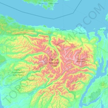
Name: Olympic National Park topographic map, elevation, terrain.
Location: Olympic National Park, Washington, United States (47.46977 -124.74259 48.27526 -123.12402)
Average elevation: 412 m
Minimum elevation: -3 m
Maximum elevation: 2,367 m
Views of the Olympic National Park can be seen from the Hurricane Ridge viewpoint. The road leading west from the Hurricane Ridge visitor center has several picnic areas and trail heads. A paved trail called the Hurricane hill trail is about 1.6 miles (2.6 km) long each way, with an elevation gain of about 700 feet (210 m). It is not uncommon to find snow on the trails even as late as July. Several other dirt trails of varying distances and difficulty levels branch off of the Hurricane hill trail. The picnic areas are open only in the summer, and have restrooms, water and paved access to picnic tables.
Other topographic maps
Click on a map to view its topography, its elevation and its terrain.
Tacoma
United States > Washington > Pierce County
Tacoma, Pierce County, Washington, United States
Average elevation: 67 m
Snohomish County
Snohomish County, Washington, United States
Average elevation: 649 m
Bellingham
United States > Washington > Whatcom County
Bellingham, Whatcom County, Washington, United States
Average elevation: 89 m
Tumwater
United States > Washington > Thurston County
Tumwater, Thurston County, Washington, United States
Average elevation: 58 m
Issaquah
United States > Washington > King County
Issaquah, King County, Washington, 98129, United States
Average elevation: 164 m
Mount Baker
United States > Washington > Whatcom County
Mount Baker, Whatcom County, Washington, United States
Average elevation: 2,699 m
Hoh
United States > Washington > Jefferson County
Hoh, Jefferson County, Washington, United States
Average elevation: 93 m
Wildlife Viewing Station
United States > Washington > Pierce County
Wildlife Viewing Station, Forest Road 280, Pierce County, Washington, United States
Average elevation: 1,312 m
Pierce County
Pierce County, Washington, United States
Average elevation: 498 m
Copalis Beach
United States > Washington > Grays Harbor County > Copalis Beach
Copalis Beach, Grays Harbor County, Washington, 98535, United States
Average elevation: 13 m
Yakima
United States > Washington > Yakima County
Yakima, Yakima County, Washington, United States
Average elevation: 377 m
Steilacoom
United States > Washington > Pierce County
Steilacoom, Pierce County, Washington, 98388, United States
Average elevation: 37 m
Decatur Island
United States > Washington > San Juan County
Decatur Island, San Juan County, Washington, United States
Average elevation: 22 m
Skagit County
Skagit County, Washington, United States
Average elevation: 753 m
Adams County
Adams County, Washington, United States
Average elevation: 461 m
Three Lakes
United States > Washington > Snohomish County
Three Lakes, Snohomish County, Washington, United States
Average elevation: 138 m
Vantage
United States > Washington > Kittitas County > Vantage
Vantage, Kittitas County, Washington, United States
Average elevation: 222 m
University Place
United States > Washington > Pierce County
University Place, Pierce County, Washington, United States
Average elevation: 72 m
Chelan County
Chelan County, Washington, United States
Average elevation: 1,094 m
Hazel
United States > Washington > Snohomish County
Hazel, Snohomish County, Washington, United States
Average elevation: 197 m
Arlington Heights
United States > Washington > Snohomish County
Arlington Heights, Snohomish County, Washington, United States
Average elevation: 136 m
Puyallup
United States > Washington > Pierce County
Puyallup, Pierce County, Washington, United States
Average elevation: 66 m
Burien
United States > Washington > King County
Burien, King County, Washington, United States
Average elevation: 65 m
Monroe
United States > Washington > Snohomish County
Monroe, Snohomish County, Washington, 98272, United States
Average elevation: 49 m
Port Ludlow
United States > Washington > Jefferson County
Port Ludlow, Jefferson County, Washington, 98365, United States
Average elevation: 64 m
Twin Falls (Lower)
United States > Washington > King County
Twin Falls (Lower), King County, Washington, 98045, United States
Average elevation: 458 m
Covington
United States > Washington > King County
Covington, King County, Washington, 98042, United States
Average elevation: 137 m
Everett
United States > Washington > Snohomish County
Everett, Snohomish County, Washington, United States
Average elevation: 66 m
Mill Creek
United States > Washington > Snohomish County
Mill Creek, Snohomish County, Washington, United States
Average elevation: 130 m
Lake Stevens
United States > Washington > Snohomish County
Lake Stevens, Snohomish County, Washington, 98258, United States
Average elevation: 82 m
Northwest Snohomish
United States > Washington > Snohomish County > Snohomish
Northwest Snohomish, Snohomish, Snohomish County, Washington, 98291, United States
Average elevation: 53 m
Edmonds
United States > Washington > Snohomish County
Edmonds, Snohomish County, Washington, United States
Average elevation: 44 m
Bothell
United States > Washington > King County > Bothell
Bothell, King County, Washington, United States
Average elevation: 68 m
Tukey
United States > Washington > Jefferson County
Tukey, Jefferson County, Washington, United States
Average elevation: 34 m
Mukilteo
United States > Washington > Snohomish County > Mukilteo
Mukilteo, Snohomish County, Washington, 98275, United States
Average elevation: 89 m
Spokane
United States > Washington > Spokane County > Spokane
Spokane, Spokane County, Washington, United States
Average elevation: 655 m
Seattle
United States > Washington > King County
Seattle, King County, Washington, United States
Average elevation: 40 m
Columbia Plateau
United States > Washington > Benton County
Columbia Plateau, Benton County, Washington, United States
Average elevation: 221 m
Port Angeles
United States > Washington > Clallam County > Port Angeles
Port Angeles, Clallam County, Washington, 98362, United States
Average elevation: 27 m
Olympia
United States > Washington > Thurston County
Olympia, Thurston County, Washington, United States
Average elevation: 49 m
Walla Walla
United States > Washington > Walla Walla County > Walla Walla
Walla Walla, Walla Walla County, Washington, United States
Average elevation: 297 m
Yakima
United States > Washington > Yakima County > Yakima
Yakima, Yakima County, Washington, 98901, United States
Average elevation: 467 m
Mount Saint Helens
United States > Washington > Skamania County
Mount Saint Helens, Skamania County, Washington, United States
Average elevation: 2,096 m
Bellingham
United States > Washington > Whatcom County > Bellingham
Bellingham, Whatcom County, Washington, 98225-3243, United States
Average elevation: 129 m
Snohomish
United States > Washington > Snohomish
Snohomish, Snohomish County, Washington, 98291, United States
Average elevation: 39 m
Kennard Corner
United States > Washington > Snohomish County > North Creek
Kennard Corner, North Creek, Snohomish County, Washington, 98205, United States
Average elevation: 92 m
The Ganges
United States > Washington > Kittitas County > Ellensburg
The Ganges, Ellensburg, Kittitas County, Washington, 98926, United States
Average elevation: 488 m
Maltby
United States > Washington > Snohomish County > Maltby
Maltby, Snohomish County, Washington, United States
Average elevation: 117 m
Steptoe
United States > Washington > Steptoe
Steptoe, Whitman County, Washington, 99174, United States
Average elevation: 736 m
Kent
United States > Washington > Kent
Kent, King County, Washington, United States
Average elevation: 87 m