
Make a donation
Adams County topographic map
Click on the map to display elevation.
Make a donation
About this map
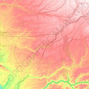
Name: Adams County topographic map, elevation, terrain.
Location: Adams County, Washington, United States (46.73541 -119.37048 47.26174 -117.95828)
Average elevation: 461 m
Minimum elevation: 108 m
Maximum elevation: 748 m
Make a donation
Other topographic maps
Click on a map to view its topography, its elevation and its terrain.
Make a donation
Lacamas Lake Shoreline Open Space
United States > Washington > Clark County > Camas
Average elevation: 106 m
Make a donation
Mount Saint Helens
United States > Washington > Skamania County
Mount St. Helens is best known for its major eruption on May 18, 1980, the deadliest and most economically destructive volcanic event in U.S. history. Fifty-seven people were killed; 200 homes, 47 bridges, 15 miles (24 km) of railways, and 185 miles (298 km) of highway were destroyed. A massive debris…
Average elevation: 2,096 m
Make a donation
Bellingham
United States > Washington > Whatcom County > Bellingham
According to the United States Census Bureau, the city has a total area of 28.90 square miles (74.85 km2), of which, 27.08 square miles (70.14 km2) is land and 1.82 square miles (4.71 km2) is water. The lowest elevations are at sea level along the waterfront. Alabama Hill is one of the higher points in the…
Average elevation: 129 m
Make a donation