
Make a donation
Spokane topographic map
Click on the map to display elevation.
Make a donation
Spokane
Spokane is located on the Spokane River in eastern Washington at an elevation of 1,843 feet (562 m) above sea level, about 18 miles (29 km) from Idaho, 92 miles (148 km) south of the Canadian border, 229 miles (369 km) due east of Seattle, and 279 miles (449 km) southwest of Calgary. The lowest elevation in the city of Spokane is the northernmost point of the Spokane River within city limits (in Riverside State Park) at 1,608 feet (490 m); the highest elevation is on the northeast side, near the community of Hillyard (though closer to Beacon Hill and the North Hill Reservoir) at 2,591 feet (790 m). Spokane is part of the Inland Northwest region, consisting of eastern Washington, north Idaho, northwestern Montana, and northeastern Oregon. The city has a total area of 60.02 square miles (155.45 km2), of which 59.25 square miles (153.46 km2) is land and 0.77 square miles (1.99 km2) is water.
Make a donation
About this map
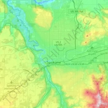
Name: Spokane topographic map, elevation, terrain.
Location: Spokane, Spokane County, Washington, United States (47.58678 -117.60400 47.75880 -117.30386)
Average elevation: 655 m
Minimum elevation: 470 m
Maximum elevation: 1,116 m
Make a donation
Other topographic maps
Click on a map to view its topography, its elevation and its terrain.
Mica Peak
United States > Washington > Spokane County
Mica Peak is the name of two separate mountain summits in the United States located approximately 5.49 miles (9 km) apart; one in Spokane County, Washington and the other in Kootenai County, Idaho. The two peaks are located along the same ridge, which separates the Spokane Valley and Rathdrum Prairie from the…
Average elevation: 1,311 m
Make a donation
Make a donation
Make a donation
Make a donation
Mica Peak
United States > Washington > Spokane County
Mica Peak is the name of two separate mountain summits in the United States located approximately 5.49 miles (9 km) apart; one in Spokane County, Washington and the other in Kootenai County, Idaho. The two peaks are located along the same ridge, which separates the Spokane Valley and Rathdrum Prairie from the…
Average elevation: 1,311 m
East Spokane
United States > Washington > Spokane County > Spokane Valley > East Spokane
Average elevation: 625 m
Make a donation