
Thank you for supporting this site ❤️
Make a donation
Make a donation
Twin Falls (Lower) topographic map
Click on the map to display elevation.
Thank you for supporting this site ❤️
Make a donation
Make a donation
About this map
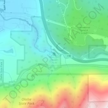
Name: Twin Falls (Lower) topographic map, elevation, terrain.
Average elevation: 458 m
Minimum elevation: 176 m
Maximum elevation: 1,167 m
Thank you for supporting this site ❤️
Make a donation
Make a donation
Other topographic maps
Click on a map to view its topography, its elevation and its terrain.
Snoqualmie
United States > Washington > King County
Snoqualmie is located at 47°31′59″N 121°50′40″W / 47.53306°N 121.84444°W / 47.53306; -121.84444 (47.532934, -121.844341), at an elevation of 410 feet (120 m) above MSL.
Average elevation: 213 m
Thank you for supporting this site ❤️
Make a donation
Make a donation