
Presidio County topographic map
Interactive map
Click on the map to display elevation.
About this map
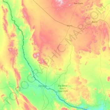
Name: Presidio County topographic map, elevation, terrain.
Location: Presidio County, Texas, United States (29.25837 -104.98075 30.62940 -103.79246)
Average elevation: 1,255 m
Minimum elevation: 716 m
Maximum elevation: 2,348 m
Geographically, Presidio County comprises 3,857 square miles (9,990 km2) of contrasting topography, geology, and vegetation. In the north and west, clay and sandy loam cover the rolling plains known as the Marfa Plateau and the Highland Country, providing good ranges of grama grasses for the widely acclaimed Highland Herefords. In the central, far western, and southeastern areas of the county, some of the highest mountain ranges in Texas are found. These peaks are formed of volcanic rock and covered with loose surface rubble. They support desert shrubs and cacti and dominate a landscape of rugged canyons and numerous springs. The spring-fed Capote Falls, with a drop of 175 feet (53 m), the highest in Texas, is located in western Presidio County. In the southern and western parts of the county, the volcanic cliffs of the Candelaria Rimrock (also called the Sierra Vieja) rise perpendicular and run parallel to the river, separating the highland prairies from the desert floor hundreds of feet below them. The gravel pediment, which allows only the growth of desert shrubs and cacti, extends from the Rimrock to the flood plain of the river. Along the river, irrigation allows the farming of vegetables, grains, and cotton. No permanent streams exist in the county, although many arroyos become raging torrents during heavy rainfalls. Major ones are Alamito Creek, Cibolo Creek, Capote Creek, and Pinto Canyon. San Esteban Dam was built across Alamito Creek and on the site of a historic spring-fed tinaja in 1911 as an irrigation and land-promotion project. Altitudes in the county vary from 2,518 to 7,728 feet (767 to 2,355 m) above sea level. Temperatures, moderated by the mountains, vary from 33 °F (1 °C) in January to 100 °F (38 °C) in July. Average rainfall is 12 inches (300 mm) per year, mainly in June, July, and August. The growing season extends for 238 days. Natural resources under production in 1982 were perlite, crushed rhyolite, sand, and gravel. Silver mining contributed greatly to the economy of the county from the 1880s to the 1940s. Presidio County has no oil or gas production.
Other topographic maps
Click on a map to view its topography, its elevation and its terrain.
Dallas
United States > Texas > Dallas County
Dallas, Dallas County, Texas, United States
Average elevation: 160 m
Nordheim
United States > Texas > DeWitt County
Nordheim, DeWitt County, Texas, United States
Average elevation: 120 m
Rio Grande
United States > Texas > Starr County
Rio Grande, Starr County, Texas, United States
Average elevation: 71 m
Pine Forest
United States > Texas > Orange County
Pine Forest, Orange County, Texas, United States
Average elevation: 5 m
San Angelo
United States > Texas > Tom Green County
San Angelo, Tom Green County, Texas, United States
Average elevation: 576 m
College Station
United States > Texas > Brazos County
College Station, Brazos County, Texas, United States
Average elevation: 87 m
Bruceville-Eddy
United States > Texas > McLennan County
Bruceville-Eddy, McLennan County, Texas, 76524, United States
Average elevation: 198 m
Mount Pleasant
United States > Texas > Titus County
Mount Pleasant, Titus County, Texas, 75455, United States
Average elevation: 115 m
Mount Pleasant
United States > Texas > Titus County
Mount Pleasant, Titus County, Texas, 75455, United States
Average elevation: 115 m
Magnolia
United States > Texas > Montgomery County
Magnolia, Montgomery County, Texas, 77353, United States
Average elevation: 77 m
Baylor County
Baylor County, Texas, 76380, United States
Average elevation: 385 m
Hudson
United States > Texas > Angelina County
Hudson, Angelina County, Texas, United States
Average elevation: 91 m
Rio Bravo
United States > Texas > Webb County
Rio Bravo, Webb County, Texas, United States
Average elevation: 130 m
Allen
United States > Texas > Collin County
Allen, Collin County, Texas, United States
Average elevation: 200 m
Levy Park
United States > Texas > Harris County > Houston
Levy Park, 3801, Greenway / Upper Kirby, Houston, Harris County, Texas, 77098, United States
Average elevation: 20 m
Boca Chica Village
United States > Texas > Cameron County
Boca Chica Village, Cameron County, Texas, United States
Average elevation: 1 m
Williamson County
Williamson County, Texas, United States
Average elevation: 222 m
Shiner
United States > Texas > Lavaca County
Shiner, Lavaca County, Texas, 77984, United States
Average elevation: 113 m
Corral City
United States > Texas > Denton County
Corral City, Denton County, Texas, United States
Average elevation: 213 m
Athens
United States > Texas > Henderson County
Athens, Henderson County, Texas, United States
Average elevation: 140 m
Amira
United States > Texas > Harris County
Amira, Harris County, Texas, United States
Average elevation: 63 m
Rock Island
United States > Texas > Colorado County
Rock Island, Colorado County, Texas, 77470, United States
Average elevation: 77 m
Grandview
United States > Texas > Johnson County
Grandview, Johnson County, Texas, United States
Average elevation: 208 m
Enchanted Rock
United States > Texas > Llano County
Enchanted Rock, Llano County, Texas, United States
Average elevation: 453 m
Elevation
United States > Texas > Milam County
Elevation, Milam County, Texas, United States
Average elevation: 150 m
Canyon
United States > Texas > Randall County
Canyon, Randall County, Texas, 79016, United States
Average elevation: 1,085 m
Corpus Christi
United States > Texas > Nueces County
Corpus Christi, Nueces County, Texas, United States
Average elevation: 8 m
Bellville
United States > Texas > Austin County > Bellville
Bellville, Austin County, Texas, United States
Average elevation: 72 m
Driftwood
United States > Texas > Hays County
Driftwood, Hays County, Texas, 78619, United States
Average elevation: 319 m
Atascocita
United States > Texas > Harris County
Atascocita, Harris County, Texas, 77346, United States
Average elevation: 19 m
Kyle
United States > Texas > Hays County
Kyle, Hays County, Texas, 78640, United States
Average elevation: 221 m
Bear Creek
United States > Texas > Hays County > Bear Creek
Bear Creek, Hays County, Texas, United States
Average elevation: 298 m
Eagle Pass
United States > Texas > Maverick County > Eagle Pass > Eagle Pass
Eagle Pass, Maverick County, Texas, 78852, United States
Average elevation: 252 m
Lago Vista
United States > Texas > Lago Vista > Lago Vista
Lago Vista, Travis County, Texas, United States
Average elevation: 251 m
Abilene
United States > Texas > Taylor County > Abilene
Abilene, Taylor County, Texas, 79697, United States
Average elevation: 549 m
Bosque County
United States > Texas > Bosque County
Bosque County, Texas, United States
Average elevation: 265 m
Longview
United States > Texas > Gregg County > Longview
Longview, Gregg County, Texas, United States
Average elevation: 105 m
Washington County
Washington County, Texas, United States
Average elevation: 87 m
Panola County
United States > Texas > Panola County
Panola County, Texas, United States
Average elevation: 89 m