
Wilson Hill topographic map
Interactive map
Click on the map to display elevation.
About this map
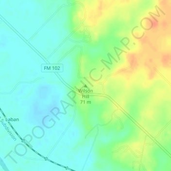
Name: Wilson Hill topographic map, elevation, terrain.
Location: Wilson Hill, Colorado County, Texas, 78935, United States (29.69019 -96.45613 29.69029 -96.45603)
Average elevation: 66 m
Minimum elevation: 50 m
Maximum elevation: 91 m
Other topographic maps
Click on a map to view its topography, its elevation and its terrain.
Wills Point
United States > Texas > Van Zandt County
Founded in 1873, Wills Point derives its name from an early American settler, William Wills, who had arrived in the area circa 1848. Wills eventually purchased a cabin from Adam Sullivan in 1852. The name 'point' may also derive from the shape of the original timberline near the cabin, though there have been…
Average elevation: 155 m
Kingsville
United States > Texas > Kleberg County
Kingsville is located in the historic Wild Horse Desert, an area of South Texas and northern Mexico where enormous herds of wild mustangs roamed. Due to water pumping and other environmental factors, the abundance of spring-fed creeks has decreased. Wildlife surrounding Kingsville include deer, wild turkey,…
Average elevation: 19 m
Stonewall County
Stonewall County Airport covers 80 acres (32 ha) at an elevation of 1,744.0 feet (531.6 m) above mean sea level (AMSL), and has one runway.
Average elevation: 535 m
Williamson County
The area is divided into two regions by the Balcones Escarpment, which runs through the center from north to south along a line from Jarrell to Georgetown to Round Rock. The county's western half is an extension of the Western Plains and considered to be within the eastern fringes of Texas Hill Country; it has…
Average elevation: 222 m