
Tunisia topographic map
Interactive map
Click on the map to display elevation.
About this map
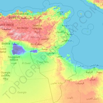
Name: Tunisia topographic map, elevation, terrain.
Location: Tunisia (30.22906 7.52198 37.76121 11.88011)
Average elevation: 240 m
Minimum elevation: -32 m
Maximum elevation: 2,237 m
Though it is relatively small in size, Tunisia has great environmental diversity due to its north–south extent. Its east–west extent is limited. Differences in Tunisia, like the rest of the Maghreb, are largely north–south environmental differences defined by sharply decreasing rainfall southward from any point. The Dorsal, the eastern extension of the Atlas Mountains, runs across Tunisia in a northeasterly direction from the Algerian border in the west to the Cape Bon peninsula in the east. North of the Dorsal is the Tell, a region characterized by low, rolling hills and plains, again an extension of mountains to the west in Algeria. In the Khroumerie, the northwestern corner of the Tunisian Tell, elevations reach 1,050 metres (3,440 ft) and snow occurs in winter.
Other topographic maps
Click on a map to view its topography, its elevation and its terrain.
Montreal
Canada > Quebec > Urban agglomeration of Montreal > Montreal
Montreal, Urban agglomeration of Montreal, Montreal (06), Quebec, H3B 1M7, Canada
Average elevation: 30 m
India
India
Average elevation: 1,017 m
Hyderabad
India > Telangana > Bahadurpura mandal
Hyderabad, Bahadurpura mandal, Hyderabad District, Telangana, India
Average elevation: 549 m
Sri Lanka
Sri Lanka
Average elevation: 50 m
Snohomish County
Snohomish County, Washington, United States
Average elevation: 649 m
Navi Mumbai
India > Maharashtra > Thane > Navi Mumbai
Navi Mumbai, Mumbai Metropolitan Region, Thane, Maharashtra, 400706, India
Average elevation: 30 m
Anaikatti
India > Tamil Nadu > Coimbatore North
Anaikatti, Mannarkad, Palakkad District, Kerala, 678741, India
Average elevation: 623 m
Jhimar
India > Uttarakhand > Molekhal
Jhimar, Molekhal, Almora District, Uttarakhand, India
Average elevation: 1,663 m
Bengaluru
India > Karnataka > Bangalore North
Bengaluru, Bangalore North, Bengaluru Urban District, Karnataka, India
Average elevation: 881 m
Colombo
Colombo, Colombo District, Western Province, Sri Lanka
Average elevation: 5 m
Sanghi
Sanghi, North Gondar, Amhara Region, Ethiopia
Average elevation: 1,181 m
Barkuru
India > Karnataka > Brahmavara taluku
Barkuru, Brahmavara taluku, Udupi District, Karnataka, 576210, India
Average elevation: 13 m
Agency Lake
United States > Oregon > Klamath County
Agency Lake, Klamath County, Oregon, United States
Average elevation: 1,266 m
Bagnoli
Italy > Campania > Benevento > Sant'Agata de' Goti
Bagnoli, Sant'Agata de' Goti, Benevento, Campania, 82015, Italy
Average elevation: 203 m
Pune
India > Maharashtra > Pune City > Pune
Pune, Pune City, Pune District, Maharashtra, 411001, India
Average elevation: 641 m
Nepal
Nepal
Average elevation: 2,604 m
Dharamshala
India > Himachal Pradesh > Dharamshala
Dharamshala, Kangra District, Himachal Pradesh, 176200, India
Average elevation: 1,781 m
Devanahalli
India > Karnataka > Devanahalli taluk
Devanahalli, Devanahalli taluk, Bengaluru Rural District, Karnataka, 562110, India
Average elevation: 900 m
Thiruvananthapuram
India > Kerala > Thiruvananthapuram
Thiruvananthapuram, Thiruvananthapuram District, Kerala, 695001, India
Average elevation: 33 m
Tacoma
United States > Washington > Pierce County
Tacoma, Pierce County, Washington, United States
Average elevation: 67 m
Haywood County
United States > North Carolina
Haywood County, North Carolina, United States
Average elevation: 1,044 m
Delhi
India > Delhi > Kotwali Tehsil
Delhi, Kotwali Tehsil, Central Delhi, Delhi, 110006, India
Average elevation: 216 m
Bhopal
India > Madhya Pradesh > Huzur Tahsil
Bhopal, Huzur Tahsil, Bhopal District, Madhya Pradesh, 462001, India
Average elevation: 498 m
Yachats
United States > Oregon > Lincoln County
Yachats, Lincoln County, Oregon, United States
Average elevation: 53 m
Nosmeh
Iran > Paveh County > دهستان شمشیر
Nosmeh, دهستان شمشیر, بخش مرکزی پاوه, Paveh County, Kermanshah Province, Iran
Average elevation: 1,778 m
Ethiopia
Ethiopia
Average elevation: 846 m
Koloriang
India > Arunachal Pradesh > Koloriang HQ
Koloriang, Koloriang HQ, Kurung Kumey District, Arunachal Pradesh, India
Average elevation: 1,791 m
Ocheretyne
Ocheretyne, Ocheretyne settlement hromada, Pokrovskii Raion, Donetsk Oblast, 86020, Ukraine
Average elevation: 227 m
Barkur
India > Madhya Pradesh > Kundam Tahsil
Barkur, Kundam Tahsil, Jabalpur District, Madhya Pradesh, India
Average elevation: 478 m
Niebuszewo-Bolinko
Poland > West Pomeranian Voivodeship > Szczecin
Niebuszewo-Bolinko, Śródmieście, Szczecin, West Pomeranian Voivodeship, Poland
Average elevation: 29 m
Kandy
Kandy, Kandy District, Central Province, 20000, Sri Lanka
Average elevation: 621 m