
Make a donation
Abkhazia topographic map
Click on the map to display elevation.
Make a donation
Abkhazia
Abkhazia is diverse geographically with lowlands stretching to the extremely mountainous north. The Greater Caucasus Mountain Range runs along the region's northern border, with its spurs – the Gagra, Bzyb and Kodori ranges – dividing the area into a number of deep, well-watered valleys. The highest peaks of Abkhazia are in the northeast and east and several exceed 4,000 metres (13,123 ft) above sea level. Abkhazia's landscape ranges from coastal forests and citrus plantations to permanent snows and glaciers in the north of the region. Although Abkhazia's complex topographic setting has spared most of the territory from significant human development, its cultivated fertile lands produce tea, tobacco, wine and fruits, a mainstay of the local agricultural sector.
Make a donation
About this map
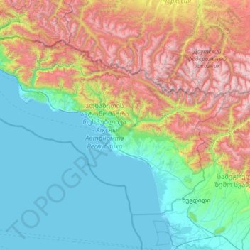
Name: Abkhazia topographic map, elevation, terrain.
Location: Abkhazia, Georgia (42.40717 39.88448 43.58643 42.14037)
Average elevation: 935 m
Minimum elevation: -4 m
Maximum elevation: 3,962 m
Make a donation
Other topographic maps
Click on a map to view its topography, its elevation and its terrain.
Make a donation
Surat
India > Gujarat > Katargam Taluka > Surat
Surat is a port city situated on the banks of the Tapi river. Damming of the Tapi caused the original port facilities to close; the nearest port is now in the Magadalla and Hazira area of Surat Metropolitan Region.It has famous beach called 'Dumas Beach' located in Hazira. The city is located at 21°10′N…
Average elevation: 11 m
Make a donation
Sirsi
India > Karnataka > Shirasi taluk
Sirsi is located at 14°37′N 74°51′E / 14.62°N 74.85°E / 14.62; 74.85 (Grid Square MK74).[3] It has an elevation ranging between 1860 feet to 2600 feet above sea level, and is situated in the heart of the Western Ghats. Sirsi is about 399 kilometres (248 mi) from Bangalore. The nearest airport…
Average elevation: 556 m
Make a donation
Nainital
India > Uttarakhand > Nainital
The city of Nainital covers a total area of 11.73 km2 (4.53 sq mi), and is located at 29°23′N 79°27′E / 29.38°N 79.45°E / 29.38; 79.45, at an average elevation of 2,084 metres (6,837 ft) above sea level. The slopes of the nearby mountains are most populated, with an elevation ranging from…
Average elevation: 1,813 m
Mumbai
Mumbai lies at the mouth of the Ulhas River on the western coast of India, in the coastal region known as the Konkan. It sits on Salsette Island (Sashti Island), which it partially shares with the Thane district. Mumbai is bounded by the Arabian Sea to the west. Many parts of the city lie just above sea level,…
Average elevation: 13 m
Navi Mumbai
India > Maharashtra > Thane > Navi Mumbai
Navi Mumbai (Marathi pronunciation: , also known by its former name New Bombay), is a planned city off the west coast of the Indian state of Maharashtra in Konkan division. The city is divided into two parts, North Navi Mumbai and South Navi Mumbai, for the individual development of Panvel Mega City, which…
Average elevation: 30 m
Make a donation
Anini
India > Arunachal Pradesh > Anini Circle
The small settlement of Anini is located at an elevation of 1,968 metres (6,457 ft) above sea level. On the Aninese Plateau, the average elevation is 1,800 meters, but the average elevation of the town is 2,068 meters. According to Google Maps' terrain feature, Anini is around 1,600–1,800 meters above sea…
Average elevation: 1,660 m
Maharashtra
Maharashtra is the third largest state by area in India. The Western Ghats better known as Sahyadri, are a hilly range running parallel to the coast, at an average elevation of 1,200 metres (4,000 ft). Kalsubai, a peak in the Sahyadris, near Nashik city is the highest elevated point in Maharashtra. To the west…
Average elevation: 478 m
Madanapalle
India > Andhra Pradesh > Madanapalle
It is located at an average elevation of 695 m (2,280 ft) above mean sea level.
Average elevation: 727 m
Make a donation
Vadodara
India > Gujarat > Vadodara Rural Taluka
Vadodara is located at 22°18′N 73°11′E / 22.30°N 73.19°E / 22.30; 73.19 in western India at an elevation of 39 metres (128 ft). It is the tenth-largest city in India with an area of 400 square kilometres (150 sq mi) and a population of 3.5 million, according to the 2010–11 census. The city…
Average elevation: 36 m
Kolkata
Spread roughly north–south along the east bank of the Hooghly River, Kolkata sits within the lower Ganges Delta of eastern India approximately 75 km (47 mi) west of the international border with Bangladesh; the city's elevation is 1.5–9 m (5–30 ft). Much of the city was originally a wetland that was…
Average elevation: 5 m
Make a donation
Make a donation
Make a donation
Tiruvannamalai
India > Tamil Nadu > Tiruvannamalai > Tiruvannamalai
Located on the foothills of Annamalai hills, Tiruvannamalai has been ruled by the Pallavas, the Medieval Cholas, the Later Cholas, Hoysalas, the Vijayanagar Empire, the Carnatic kingdom, Tipu Sultan, and the British. It served as the capital of the Hoysalas. The town is built around the Annamalaiyar Temple…
Average elevation: 202 m
Make a donation
Dehradun
India > Uttarakhand > Dehradun
The city of Dehradun mainly lies in Doon Valley and is at a varying height from 410 m (1,350 ft) in Clement Town to above 700 m (2,300 ft) at Malsi which is 15 km (9.3 mi) from the city. However, the average elevation is 450 m (1,480 ft) above sea level. Malsi is the starting point of Lesser Himalayan Range…
Average elevation: 904 m
Make a donation
Shimla
Shimla is on the south-western ranges of the Himalayas at 31°37′N 77°06′E / 31.61°N 77.10°E / 31.61; 77.10. It has an average altitude of 2,206 metres (7,238 ft) above mean sea level and extends along a ridge with seven spurs. The city stretches nearly 9.2 kilometres (5.7 mi) from east to west.
Average elevation: 1,557 m
Make a donation
Sudarshan Parbat
India > Uttarakhand > Bhatwari
Sudarshan Parbat is a mountain of the Garhwal Himalaya in Uttarakhand India.The elevation of Sudarshan Parbat is 6,529 metres (21,421 ft) and its prominence is 456 metres (1,496 ft). It is joint 87th highest located entirely within the Uttrakhand. Nanda Devi, is the highest mountain in this category. Sudarshan…
Average elevation: 5,792 m
Make a donation
Make a donation
Make a donation
Make a donation
Make a donation
Tallahassee
United States > Florida > Leon County > Tallahassee
Tallahassee's terrain is hilly by Florida standards, being at the southern end of the Red Hills Region, just above the Cody Scarp. The elevation varies from near sea level to just over 200 feet (61 m), with the state capitol on one of the highest hills in the city. The city includes two large lake basins, Lake…
Average elevation: 32 m
Make a donation
Vagamon
Vagamon, due to its elevation and climate, has a unique ecosystem, leading to the emergence of rich natural vegetation, plant species, shola forests etc. From the early 20th century plantation crops like tea, coffee started. Vagamon hills are home to less explored flora and fauna. A faunal diversity study…
Average elevation: 866 m
Ankara
Ankara has a cold semi-arid climate (Köppen climate classification: BSk). Under the Trewartha climate classification, Ankara has a temperate humid continental climate (Dc). Due to its elevation and inland location, Ankara has cold and snowy winters, and hot and dry summers. Rainfall occurs mostly during the…
Average elevation: 1,082 m
Make a donation
Make a donation
Make a donation
Make a donation
Puttur
India > Karnataka > Putturu taluk
Puttur is located at 12°45′53″N 75°11′03″E / 12.7648°N 75.1842°E / 12.7648; 75.1842. It has an average elevation of 87 m (300 ft). Puttur is situated 52 km (32 mi) south-east of Mangalore city.
Average elevation: 110 m
Khammam
India > Telangana > Khammam Urban mandal
Khammam is located at 17°15′N 80°09′E / 17.25°N 80.15°E / 17.25; 80.15. It has an average elevation of 108 metres (390 feet).
Average elevation: 130 m
Make a donation
Make a donation
Make a donation
Chennai
Chennai is located on the south–eastern coast of India in the north–eastern part of Tamil Nadu on a flat coastal plain known as the Eastern Coastal Plains. Its average elevation is around 6.7 metres (22 ft), and its highest point is 60 m (200 ft). Chennai is 2,184 kilometres (1,357 mi) south of Delhi,…
Average elevation: 7 m
Dahegam
India > Gujarat > Dehgam Taluka
Dahegam is located at 23°10′N 72°49′E / 23.17°N 72.82°E / 23.17; 72.82. It has an average elevation of 73 metres (239 feet).
Average elevation: 76 m
Make a donation