
Ho Chi Minh City topographic map
Interactive map
Click on the map to display elevation.
About this map
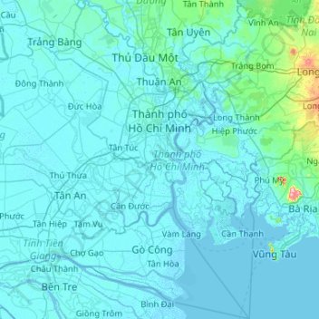
Name: Ho Chi Minh City topographic map, elevation, terrain.
Location: Ho Chi Minh City, Vietnam (10.13995 106.35670 11.16031 107.02767)
Average elevation: 17 m
Minimum elevation: -4 m
Maximum elevation: 492 m
The city is located in the south-eastern region of Vietnam, 1,760 km (1,090 mi) south of Hanoi. The average elevation is 5 m (16 ft) above sea level for the city centre and 16 m (52 ft) for the suburb areas. It borders Tây Ninh Province and Bình Dương Province to the north, Đồng Nai Province and Bà Rịa–Vũng Tàu province to the east, Long An Province to the west, Tiền Giang Province and East Sea to the south with a coast 15 km (9 mi) long. The city covers an area of 2,095 km2 (809 sq mi or 0.63% of the surface of Vietnam), extending up to Củ Chi District (12 mi or 19 km from the Cambodian border) and down to Cần Giờ on the Eastern Sea. The distance from the northernmost point (Phú Mỹ Hưng Commune, Củ Chi District) to the southernmost one (Long Hòa Commune, Cần Giờ District) is 102 km (63 mi), and from the easternmost point (Long Bình ward, District Nine) to the westernmost one (Bình Chánh Commune, Bình Chánh District) is 47 km (29 mi). Due to its location on the Mekong Delta, the city is fringed by tidal flats that have been heavily modified for agriculture.
Other topographic maps
Click on a map to view its topography, its elevation and its terrain.
Tân Lạc District
Tân Lạc District, Hoà Bình province, Vietnam
Average elevation: 416 m
Phan Thiết City
Phan Thiết City, Bình Thuận Province, Vietnam
Average elevation: 40 m
Cao Lanh City
Cao Lanh City, Đồng Tháp Province, Vietnam
Average elevation: 5 m
Quảng Yên
Quảng Yên, Quảng Ninh Province, Vietnam
Average elevation: 25 m
Vung Tau City
Vietnam > Bà Rịa - Vũng Tàu Province
Vung Tau City, Bà Rịa - Vũng Tàu Province, Vietnam
Average elevation: 3 m
Tân Yên
Vietnam > Tuyên Quang Province > Hàm Yên District
Tân Yên, Hàm Yên District, Tuyên Quang Province, Vietnam
Average elevation: 87 m
Xã Hàm Tân
Vietnam > Trà Vinh Province > Trà Cú District
Xã Hàm Tân, Trà Cú District, Trà Vinh Province, Vietnam
Average elevation: 2 m
Tuần Châu
Vietnam > Quang Ninh Province > Hạ Long City
Tuần Châu, Hạ Long City, Quảng Ninh Province, Vietnam
Average elevation: 1 m
Điện Biên Phủ
Điện Biên Phủ, Điện Biên Province, Vietnam
Average elevation: 893 m
Vị Dương
Vietnam > Quang Ninh Province > Quảng Yên
Vị Dương, Quảng Yên, Quảng Ninh Province, Vietnam
Average elevation: 2 m
Phuoc Hoa Ward
Vietnam > Bà Rịa - Vũng Tàu Province > Phú Mỹ Town
Phuoc Hoa Ward, Phú Mỹ Town, Bà Rịa - Vũng Tàu Province, Vietnam
Average elevation: 18 m
Da Lat City
Da Lat City, Lâm Đồng Province, Vietnam
Average elevation: 1,322 m
Ninh Bình
Ninh Bình, Ninh Binh province, 08000, Vietnam
Average elevation: 5 m
Tây Ninh City
Tây Ninh City, Tay Ninh province, Vietnam
Average elevation: 28 m